


A River Ran Through It: Historical Golden Meadow as Gateway to the Gulf
By John P. Doucet
The town of Golden Meadow, Louisiana, is the southernmost incorporated area of Lafourche Parish. It occupies both banks of Bayou Lafourche along Louisiana Highways 1 (LA 1) and 308, which closely parallel it, and lies between the villages of Galliano to the northwest and Leeville to the southeast (Fig. 1). During the course of its nearly 120 years atop southeastern Louisiana marshland, it has been transformed from a small farming enterprise, to a modest settlement of fishermen, to a rapidly growing seafood processing center, to an oilfield drilling and services center, to now a small residential town. It was there where I was born and raised, observing much of this transformation during the 1960s and 1970s.
The town is infamously known to many travelers as the speed-trap on the way to Grand Isle and the Gulf of Mexico. And for as long as I can remember, I have known that a prehistoric path of the Mississippi River runs through it.
Vantage Point
I spent many days visiting my maternal grandparent's home at 1023 North Bayou Drive. Their home was an early twentieth century craftsman bungalow with two gables and a down-sloping front roof overhanging a house-width screen porch. Like many wooden-frame homes surrounding it, it was narrow and long to fit the dimensions of a bayoufront lot. It was painted a soft powdery white and was raised about three feet above ground on concrete house piers.1 With the house at the front of this narrow strip, the back yard was home to a tool shed, a cistern, a pen for egg-laying ducks, and a multipurpose fish-cleaning, oyster-shucking, turtle-shelling, and shrimp-peeling shed. The continuous stretch of such properties along Bayou Lafourche, with narrow bayou frontage and longer stretches of land to the rear, gave rise to the epithet "longest street in the world" 2 for Lafourche Parish and particularly its 10th Ward,3 which lies south of the Gulf Intracoastal Waterway (Intracoastal Canal; Borne 1944, Chapin 1962, Ditto 1980).
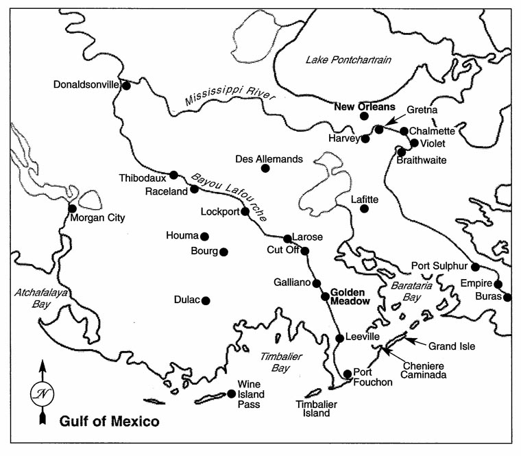
My parental home was built in the late 1950s, and by that time Golden Meadow was incorporated and had grown to the point that streets and subdivisions developed away from and perpendicular to LA 1 toward the marsh to the west of town. Our home was built down the aptly named Palmetto Lane. Because our home was built on a street some distance from the bayoufront, it was from the rocking chairs of my grandparents' screen porch, sharing occasional Gulf breezes and French-English conversations with them over the years, where I watched the town's transformation. My vantage crossed the town's sidewalk, 4 LA 1, and the bayou, each of which was a busy avenue of transit across town.
Community Origins, Early Settlement, and Township
According to town history (Rome 1996), the first settlers to the area traveled by boat from Natchez, Mississippi, and arrived at the lower reaches of the bayou in 1842.5 Despite the French-Acadian ancestry of the historical town population, surnames of original settlers were non-Acadian, including, Lush, York, Williams, Griffin, and Barker. Other early settlers with French (but non-Acadian) surnames included Rouse, Callais, and Cheramie. The latter two settlers gave rise to large families still living in the area; in fact, it is a commonly-held notion that all the Cheramies6 in Louisiana live in Golden Meadow (West 1966) or are ancestral to the town. These early settlers were attracted to vast expanses arable marshland with rich, organic soils; fishing, trawling, and hunting and trapping were largely incidental. In 1903, Callais sold land to an anonymous "Yankee" from Michigan7 for construction of a canal from Bayou Lafourche through the eastern marsh to facilitate land drainage in advance of reclamation farming. For this reason, the original settlement of about eight homes became known in French as Canal Yankee, or "Yankee Canal." Sometime between early settlement and 1915, the name "Golden Meadows" came into wide usage.8
Though more families of diverse origins would settle at Yankee Canal, particularly those interested in farming and promises of the land reclamation boom at the beginning of the 20th century (Harrison and Kollmorgen 1947a and 1947b), the area rapidly attracted descendants of the mass Acadian settlement that occurred at the northern end of the parish near and upstream of Thibodaux in 1785. Due to forced heirship laws, as well as economic downturns and the 1820 arrival of planters interested in purchasing bayou farmlands from the Acadian petit habitants, descendants of the 1785 Acadian settlers purchased land and established small bayoufront farms progressively southward along the bayou, reaching coastal Louisiana and its ample fishing and trawling areas in only a few generations9 and settling along the way. The extended area surrounding Yankee Canal was an attractive area for settlement not only for the potential of farming and fishing but also for the dense growth of moss-adorned live oak trees that represented a ridge of land higher than the more marshy and flood-prone surroundings.10
The largest influx of these Acadian descendants to the settlement, however, was not directly from land at the upper reaches of the bayou. Rather, it was a succession of three major hurricanes near the turn of the twentieth century that forced Acadians, Native Americans, and a multi-cultural diversity of coastal settlers to retreat from the Gulf. The Great Cheniere Hurricane of 1893 (Looper, Charpentier, and Doucet 1993), which destroyed the densely-populated coastal fishing village of Cheniere Caminada,11 drove many surviving families from the coastal cheniere fan12 up Bayou Lafourche to resettle in the area of the Golden Meadow oak ridge,13 as well as the more southern settlement known as Leeville.14 With advanced boat building and introduction of in-board engines,15 it became economically feasible for fishermen to relocate to more inland property and away from the immediate impact of storms, establishing the major economic force of these settlements. Subsequent hurricanes of 1909 and 1915 inundated Leeville with catastrophic tidal surges, and the latter destroyed nearly all buildings in the village.16
These three storms are known as the "triumvirate." Their collective impact caused a rapid population expansion of the Golden Meadow village, the settler majority of which was afterwards French-speaking Catholics. This expansion prompted the Diocese of New Orleans in 1916 to establish a new Catholic church in the area:17 "[The] congregation is made up principally of humble fisher folk, many of whom are survivors of the terrible storm which devastated Cheniere Caminada" (New Parish 1916). With a major sector of Louisiana's coastal fishing fleet relocated to Golden Meadow, the village incurred rapid growth and would soon become a major seafood selling and processing center for the state.
When oil was discovered in neighboring Leeville in 1931, Golden Meadow served as a service hub for the influx of men and machines passing through the area. Four years later, Leeville was home to 61 oil wells (Mumphrey and Wagner 1976). Many of these out-of-town workers utilized food and residence services in Golden Meadow. Because many were experienced oil field workers from Texas (or were working for Texaco at the time), cultural friction with the inexperienced locals developed, leading to the rise of infamous epithets between groups.18
Then, in 1938, oil was discovered in Golden Meadow proper by the Bennett Oil Company (Rome 1996), and soon oil field service rivalled seafood processing as a major economic force in the village. A skyline of drilling derricks rose above town. Shrimpers, trappers, and fishermen became oil field workers which, unlike traditional occupations, offered a multitude and diversity of jobs, an opportunity for continuous work, and a regular paycheck. In addition, Golden Meadow would serve the natural gas and sulfur producing industries as they rose, beginning in 1938 and 1955 respectively (Mumphrey and Wagner 1976). Despite the rise of oil, however, seafood production remained strong. By 1944, 48 million pounds of ice were produced by Golden Meadow ice plants to ship shrimp and oysters around the world (Borne 1944). By the 1950s, Golden Meadow held the titles "capital of the Lafourche oil industry" and "home port of the Lafourche fishing fleet" (Yoes 1954).
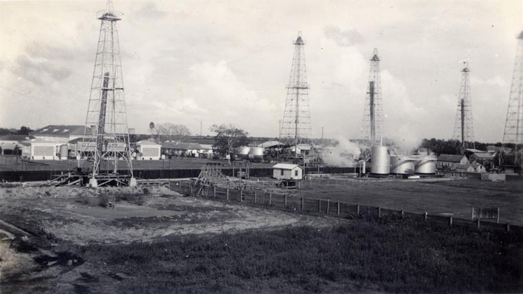
In the early days of inland oil exploration, there were few drilling regulations, and often landowners signed agreements without realizing or otherwise being apprised of consequences. In that environmentally unregulated era, drilling operations often invaded homeowners' yards with trucks and mud and pipe and well wastes (Fig. 2a). Successful wells became sights of "rocking horse" pumps (a.k.a. pumpjacks) and associated oil storage tanks, which frequently littered neighborhoods and back marshes and sometimes incurred spills. One notorious incident occurred in Fall 1939, when a well drilled by Bennett Oil, located just behind the high school and about 2000 feet from the bayoufront residential area, suffered a major blowout. The eruption began October 23rd when a pocket of trapped subterranean gas was breached, destroying the drilling derrick and spewing noxious gas, rocks, saltwater, and oil for a three-mile radius. During the six-week rain of pollutants, townsfolk suffered contaminated cisterns, destroyed house roofs, and spoiled farms and gardens as well as the constant roar of rushing gas that could be heard for miles. School and businesses in the vicinity were shut down and several families relocated. My maternal grandfather, a life-long asthmatic, left his home and temporarily relocated farther upstream near his father's house on the north end of town. The well spontaneously sanded-over on December 5th.
By the middle of the twentieth century, residents recognized the need for local government, local taxation, and political representation. After three failed attempts, a fourth application for town incorporation, sponsored by the Golden Meadow Women's Club, was finally effectuated on July 17, 1950, by signature of Gov. Earl Long. Incorporation defined the town limits to an approximately three-mile length along Bayou Lafourche and a total area of just under three square miles. In addition to the sizeable population of 3000 at the time (James 2001), the population density of Golden Meadow was much higher than the rest of Lafourche Parish and the state.19 In 1944, Police Jury President Leon Borne noted that one third of all votes in a recent parish election were cast in Golden Meadow alone (Borne 1944).
Family History and Migration
My family history represents many of the forces that helped establish the town of Golden Meadow as well as being representative of the history of many families living in the 10th Ward of Lafourche Parish. Interestingly, my ancestors settled there from opposing geographical directions—and from the Gulf Coast near its end. As well, their occupational transitions represent the evolution of the town's economy. My paternal ancestors were part of the original 1785 Acadian settlement at the northern end of the future Lafourche Parish, as well as the subsequent migration of descendants down Bayou Lafourche to the coast. My maternal ancestors, on the other hand, first settled at the coast and migrated upstream to Golden Meadow after suffering the triumvirate of storms.
The Doucet lineage on Bayou Lafourche began seven generations before me, when a young Jean-Baptiste, his brother, and their widowed mother boarded the frigate L'amitie at Nantes, France. After thirty years of attempted repatriation in France following the Exile, they made the trans-Atlantic voyage to New Orleans aboard one of the famous Seven Ships20 that carried the largest single migration of Acadians to Louisiana. They were resettled by the Spanish territorial government on a bayoufront land grant on the east bank of Bayou Lafourche just south of present-day Thibodaux and adjacent to present-day Laurel Valley Plantation Historical Site (Westerman 1995). Just five years after the arrival of American planters in 1820 and the economic turmoil caused by large farming enterprises, the property of Jean-Baptiste was in probate and distributed to his children. Under Louisiana's forced heirship laws, where once he farmed 450 arpents (about 375 acres) of fertile bayoufront property, each of his children by law received an equal fractional share of land. As a consequence of these laws, original Acadian farms would be reduced over 1-2 generations to uneconomical slivers of bayoufront property.
Like many Acadian families, his children and grandchildren sought land sequentially farther down Bayou Lafourche. Three generations after Jean-Baptiste, his descendant Joseph Celestin was a coastal fisherman at Cheniere Caminada (see Note 9). Joseph's grandson, Celestin Joseph (1884-1939), was a shrimp trawler at Leeville who, after the 1915 hurricane, became the first family settler in Golden Meadow. Celestin's son, my grandfather Etienne (1907- 1985), was born at Leeville. At first, Etienne was an itinerant farmer, living with his young family in a houseboat moored on the bayouside, as was the practice of many landless early settlers (Rome 1996). He eventually purchased property in Golden Meadow and lifted the houseboat onshore, placing it atop concrete house piers and establishing his first home on land. Etienne eventually transitioned from farming to working in the trawling industry, serving as an ice man in the bows of large shrimp boats to cover daily catches with ice for preservation. He eventually purchased a shrimp boat and became a self-employed trawler. In later years, he transitioned to working in the oil field service industry. Like many men in town, he worked for Texaco, which owned an abundance of drilling leases in Golden Meadow and Leeville. His son Herman (1928-74), my father, worked exclusively in the oil industry, eventually becoming a tool pusher on a drilling barge that tapped the shallow-water oil deposits in lakes and waterways in southern Louisiana. My father was first in the family lineage to be born in Golden Meadow and represents the only generation to work exclusively in the oil industry.
My maternal lineage is Rebstock and derives from Germany. The progenitor, John Rebstock (1848-1914), was an orphaned preteenager who was hired from foster care in New Orleans by an oysterman named Victor Petite, who lived at Cheniere Caminada and delivered his oyster catches to the city on a regular basis. Rebstock eventually became a self-employed oysterman with a fleet of three boats. In the Great Cheniere Hurricane of 1893, his home imploded during the tidal surge and the pyramidal rood was carried by waves to the apex of the cheniere fan. Under the roof, 62 lives were saved during the storm.21 Following the storm, he relocated his family to Leeville and transitioned to a storeowner, providing supplies and services to oystermen and their boats. He survived the 1909 Leeville hurricane and died one year prior to the 1915 Leeville Hurricane. His son Armond ("T-Mom," 1878-1960), my great-great grandfather, was also an oysterman and first in the family to live in Golden Meadow. Armond's son, George (1905-1977), my grandfather, followed the family tradition as an oysterman, as well as subsequently holding other jobs as the town's economy diversified. He served Golden Meadow for many years in law enforcement and retired as deputy sheriff of Lafourche Parish. He is father of my mother, Dora Rebstock (1930-2009), who was a housewife and later a catalog and service counter attendant at a local retail sales office. She, like my father, is first in her extended family lineage to be born in Golden Meadow.22
By the time of the 1893 hurricane, 7 of my 8 great-grandparents lived at Cheniere Caminada. Both the Doucet and the Rebstock lineages intermittently settled in Leeville and then after the 1915 storm relocated to Golden Meadow. Ancestry to 19th century Cheniere Caminada is characteristic of many families in Golden Meadow and the 10th Ward of Lafourche Parish.23 The impact of the triumvirate of storms cannot be overestimated in not only growing the settlement of Canal Yankee into the town of Golden Meadow but also determining settlement patterns of lower Bayou Lafourche and the Barataria Basin.
A Gateway Town
Only twenty miles separated the original settlement at Yankee Canal from the coastal terminus of Bayou Lafourche as it bifurcates into Belle Pass and Pass Fourchon.24 Since the early days of settlement, Bayou Lafourche has served as the region's only outlet to Leeville, the Gulf, coastal marshes, Cheniere Caminada, and Grand Isle, and the oak ridge of Golden Meadow has served as a convenient outpost. The collapse of coastal communities following the great storms of 1893, 1909, and 1915, sealed Golden Meadow's fortune, as retreating families of fishermen relocated their homes and fishing operations away from the coast, rapidly increasing the village's population.
In the early days, there were likely few purely recreational boats, as the bayou and watery marshlands surrounding Golden Meadow represented means of subsistence and economic survival. The bayou primarily served small, privately-owned fishing boats of self-employed fishermen. Among the fishing boats were small, shallow draft vessels powered by oar and sail that were easy to maneuver through small lakes and bays. These craft, such as simple chalands, pirogues, and small skiffs also served well during the rise of marsh channelization, as narrow tranasses were carved in the marsh to improve access to fishing and hunting grounds and canals were dredged to improve boat and barge access to drilling and production sites.
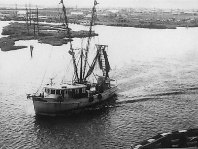
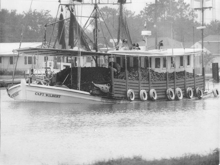
Sail and oar were soon replaced after the 1902 introduction of motor engines onto existing boats (see Note 15). With engines, boats could not only travel faster and longer distances in a single day but also could be made bigger and carry heavier loads. The Lafitte Skiff,25 a small craft unique to southern Louisiana, became the workhorse of the private fisherman and trawler. Larger, wooden-hull, cabin-front Floridian shrimp trawlers with their long trawls dangling from tall, rear-mounted booms became prominent (Padgett 1969). As years passed, larger, steel-hulled Floridians appeared (Fig. 3a). Rear-cabin oyster luggers often so heavied with their catch as to seem riding below bayou level were also frequent as they returned from the reefs located just offshore (Fig. 3b). During the rapid growth of the fishing industry and the rise of large boats in Golden Meadow, chalands and Lafitte skills remained prominent for private and recreational fishermen and were commonly seen moored on bayouside docks made of creosote-coated posts and planks, as nearly each bayouside home along LA 1 had one. As early as 1944, the commercial fishing fleet numbered 300 (Louisiana 1941).
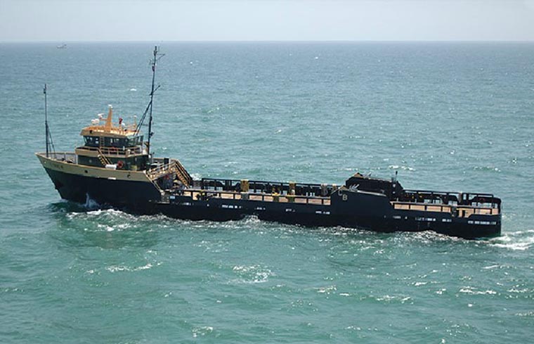
To supply the inland oil drilling industry of the Leeville Field and the Golden Meadow Field,26 tug boats and supply barges began arriving in town. With the discovery of oil offshore of Lafourche Parish in Bay Marchand in 1949 (Mumphrey and Wagner 1976), the bayou became the gateway to offshore exploration, and larger tugs and barges, together with privately owned crew boats, specialty boats delivering chemicals and instrumentation, and sometimes drilling barges with deconstructed derricks lain across the top of equipment and housing were tugged across the bayou. The need for delivering supplies to offshore operations gave rise to multiple boatbuilding companies, including one that invented a new type of supply vessel—the botruc.27 Major vessels carrying equipment and supplies to the oil field from manufacturing centers traveled to Bayou Lafourche through the Intracoastal Canal, which was completed in 1949 but segmentally operational as early as 1936 (Alperin 1983). This east-west canal intersected the north-south bayou at Larose, La., some 15 miles northwest of Golden Meadow.
In 1903, the same year that Bayou Lafourche was dammed at its origin at Donaldsonville, La.,28 a dirt road built atop the shallow natural bayou levee reached the lower lands of the Lafourche Parish at Golden Meadow. The road closely paralleled the bayou, with only a few feet of land between it and the stream, and ran between Bayou Lafourche and homes of bayoufront property owners. The road was graveled29 nearly 20 years later in 1922 and then paved in concrete in 1936 after a further 14 years, suggesting that the bayou remained the primary avenue of transportation during these decades. Nonetheless, the concrete highway facilitated truck and personnel transportation to the Leeville Oil Field and anticipated discovery of the Golden Meadow Oil Field two years later (Fig. 4).
Paved roads meant safer and faster transportation, but Golden Meadow maintained a restrictive speed limit of 30 m.p.h. on LA 1—the lowest limit in Lafourche Parish—giving the town a historical notoriety among travelers to Grand Isle and Gulf. Primarily, the lower speed increased the safety of the homeowner as he frequently crossed the road carrying fishing gear or seafood to and from his home. In addition, the town was largely pedestrian before the road was built, and the increasing number of businesses demanded by an increasing population and diversifying economy meant an increase in pedestrian traffic.
Gateway Town Commerce
The dramatic increase in water traffic on Bayou Lafourche resulting from the seafood and drilling industries created a concomitant increase in road traffic, and nascent businesses along LA 130 in Golden Meadow met travelers' needs. Already a seafood hub when oil was discovered, Golden Meadow saw a steady increase of both workers, visitors, and land purchasers needing residence, meals, and entertainment.
The 1922 Sanborn Map of Golden Meadow31 show a streetless, linear town of population 500. Homes and business are narrowly separated from Bayou Lafourche by "La Fourche Road." Less than 20 years following the establishment of Canal Yankee as a farming enterprise, Golden Meadow had entered the seafood processing industry, already home to two large shrimp canneries, each with bayouside docks for visiting boats and one connected to a shrimp drying platform.32 Among the other 109 non-residential structures are a Roman Catholic Church, a high school, a bank, a moving pictures theater, two dance halls, three pool halls, three barbers, a boat shop, and four general stores (Sanborn 1922).
A major impetus in town commercial growth was the invention of large ice factories (Fig. 6). The ability to pack shrimp and other seafood on ice kept it fresh and facilitated longer carriage, increasing the ability of trawlers to explore offshore environments and leading to the development of larger boats, as well as creation of a seafood packing and shipping industry. When once the fishermen of Cheniere Caminada needed to sail their daily catch of fish, crabs, shrimp, and oysters north through Barataria Bay to a "Lugger's Landing" near present-day Harvey to supply the New Orleans market (Looper, Charpentier, and Doucet 1993), their descendants now had their catch packaged fresh and shipped to New Orleans and beyond. Following the 1915 storm, the first "ice house" was built by the Gulf Coast Shrimp Company through funds generated from sales of stock shares (Rome 1996).
In addition to an increasing number of boat shops and boat builder operations, the seafood industry was served by businesses catering to the special needs of oystermen and trawlers, both commercial and private.33 Of note was the rise of trawl board and net shops across town. Trawl nets and the wooden boards to keep them open as they dragged waterbeds were often made by the same carpenter boat-builders that worked on shops atop pilings overlooking the bayou banks. Location of such net and board specialty enterprises to the north and south ends of town and outside the dense residential area suggests that this service was a later development. One of these shops on South Bayou Drive was Joe Doucet and Son Trawl Boards, founded by my great uncle Joseph Doucet.
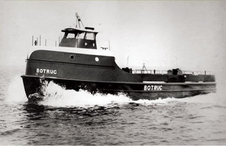
Service to the oil industry also increased between 1938 and the downturn in the 1970s. Some fishermen leased or repurposed their wooden-hulled boats to carry shift workers from bayouside docks to inshore and offshore drilling facilities. These boats were soon replaced by specially-designed steel-hulled vessels aptly called "crew boats". The prominent shipbuilding industry of southern Lafourche Parish developed from small companies in and around Golden Meadow. Specialty tug boats like "botrucs" (Fig. 3c and d; see Note 27) and their associated leasing companies also rose to prominence. Onshore, properties were purchased and leased by companies to establish oil field supply yards that held drilling pipe and other equipment for lease by drilling enterprises. One longstanding establishment on North Bayou Drive offered cleverly named "fishing tools" equipment to recover pipe and other drilling items lost in well holes.
Like any rural area in the U.S., availability of household food and supplies underwent transition in the 20th century. The first grocery store was opened in 1906, followed by a second in 1912 (Rome 1996). Also, in the early days of town, a boat made weekly deliveries along Bayou Lafourche between Golden Meadow and neighboring communities to the north. Often, proprietors sold items through home delivery from trucks that drove along LA 1. During my childhood, I remember door-to-door purveyors including dry cleaners, insurance salesmen, ice cream trucks, and "the Egg Lady" who delivered fresh chicken or duck eggs to home. On each designated delivery day, my mother ensured that she was home to conduct business with these visiting sellers.
Private supermarkets rose in the 1960s, not only because of the town's peaking population but also because of industry needs. At a time when a bi-weekly grocery bill for a home was often $5-$10 in total, a "boat order" for carriage on a large trawler or a "rig order" for delivery to a drilling enterprise could exceed $500.
The town boasted several meat markets independent of grocery stores. Much of the prairieland along Bayou Lafourche outside of the residential areas on both sides of town was left undeveloped and utilized for cattle farming, and local butcheries were a natural development. My great uncle Arcelone Doucet owned a large herd and market on South Bayou Drive. Like many lowland prairie businesses in the area, his suffered consequences of storms and flooding. In the aftermath of flooding from Hurricane Betsy in 1965, he relocated surviving cattle to Delta Farms;34 he subsequently lost the rest of his herd when Delta Farms flooded for the last time in 1971.
In addition to supermarkets, seafood and oil industries transformed other town businesses. For home and business cash management, State Bank and Trust of Golden Meadow became a long-time financial establishment and was followed by branches of out-of-town banking operations. Privately-owned stores for fine clothing as well as merchandise franchises like Western Auto appeared in town in the 1960s. The large, wooden-frame Marshland Hotel was gone by then: It sported a dryland frontage along LA 1 and a wet rear, where the hotel's wide dock faced Bayou Lafourche, making the establishment accessible by both car and boat. Saloons were not uncommon, particularly down South Bayou Drive.
The Modern Residential Town
Golden Meadow is historically one of the more densely populated town areas in Louisiana. Settlement typically follows the line-pattern of land development, forming a continuous ribbon of small properties along the bayou, especially along LA 1. In the early days, the town was streetless, but as the populations grew and diversified, a nuclear family and its decent could be easily located by street. Streets were commonly bore the surname name of the original bayoufront landowner. Still today, you can find Pierce Street, Toups Lane, Williams Road (see Note 5), Callais Lane, and Dursette Lane.35 Off North Bayou Drive, you can also find streets named after given names, including Fred Street, Bo's Lane, Eddie Lane, Cliff's Lane.
Homes on the bayoufront built by progenitors were mostly cottages and bungalows painted white like their boats across the highway moored to bayouside docks. Father down each street, houses become more modern-styled, and travelers can easily find a sixties-era shallow roofed brick home down a street fronted by a historical wooden white cottage. In the modern town, the bayoufront property of some older homes has been repurposed for newer homes and businesses.
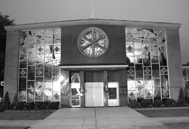
The center of town is traditionally placed at the Our Lady of Prompt Succor Church on LA 1, and this bayouside location divides North Bayou Drive and South Bayou Drive. The Catholic parish was originally established as St. Yves Parish in March 1916 (Our Lady of Prompt Succor 2016), but the name was changed in late 1917.36 Originating as a quaint wooden structure surrounded by mossy oaks, the church was built on a slight east-west turn of the bayou such that boats traveling upstream from the Gulf (the direction traveled by settlers after the triumvirate of storms) can view the building unimpeded by its surroundings. The modern church building, completed in 1958, is a large red-brick structure with large front window panes facing the bayou. The panes were recently replaced with stained glass depicting abstract images of fish, Gulf waves, and trawl nets as homage to the town's traditions (Fig. 2b). To the immediate rear of church is a historical cemetery that inters many of the early settlers of the community. My parents and grandparents as well as other relatives are also buried here.37
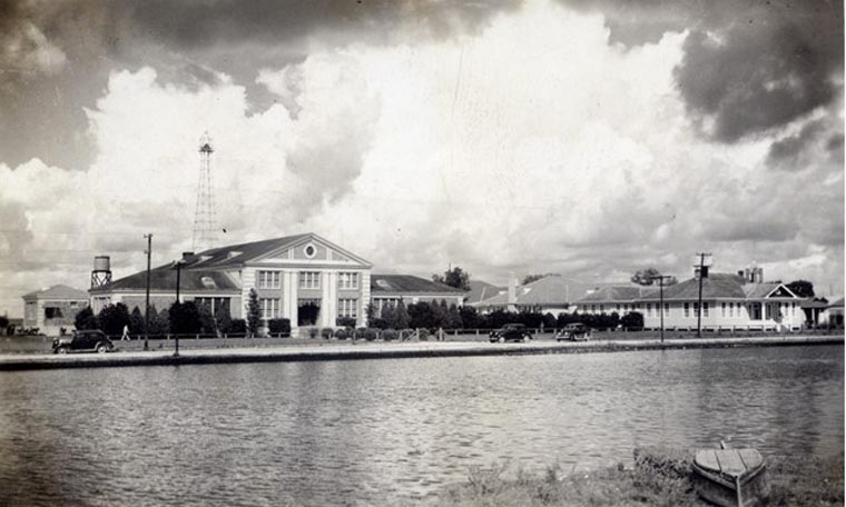
After holding school sessions in borrowed spaces (Rome 1996), a proper public schoolhouse was eventually built to serve the educational needs of the seafood boom town. The magnificent Golden Meadow High School building (Fig. 2c) is listed on the National Register of Historical Places. This tall, imposing structure in the Classical Revival style dramatically contrasts with the line of small cottage and businesses surrounding it. Preceded by large wooden buildings, some of which remain on the property, this structure of auditorium and peripheral classrooms was completed in 1931 (Golden Meadow High School 2019). With population increases since its construction, two classroom annexes, a gymnasium, cafeteria, and football stadium were subsequently added. Following school reorganization (a function of changing population), the building became a junior high school in 1967 and currently operates as a middle school.38
Such public schools, however, were not always open to all people. Until 1964 in Louisiana, Native Americans were restricted from attending public schools, and, like neighboring Terrebonne Parish, Lafourche Parish built a "settlement school" for their education. The Lafourche school was established near Golden Meadow on LA 1 just south of the corporation limits. It was here that a large community of Houma39 had previously established residence along Bayou Lafourche, numbering 175 by 1911 (Swanton 1911) and 300 by 1940 (Parenton 1950), approximating one-fourth of the total Houma population of those years. Like much of the storm-displaced population of town, some families of the Houma nation migrated east to Bayou Lafourche from their homes in the marshes of western Terrebonne Parish following destruction of their villages in the 1915 storm. Others remained in multiple smaller villages interspersed in the marshes. One such village, named Fala,40 was located on the northwestern shore of Catfish Lake in the marshes directly west of Golden Meadow. To get to school, children first boated across the lake to the back of town and then walked several miles to the schoolhouse. In addition to cottage-style homes along LA 1, a small Houma group living in palmetto huts remained south of Yankee Canal at the end of Highway 308 until being uprooted by Hurricane Betsy in 1965. This community existed on the eastern bank of the bayou near six large oil storage tanks that spelled T-E-X-A-C-O.
Early settlers were subsistence farmers, fishermen, and homeowners, and historically both men and women knew and practiced home cooking skills. However, as the town industrialized, the lunchtime needs of the multitude of daily workers at seafood factories and drilling enterprises gave rise to food delivery services, which, together with the rising affluence of townsfolk, encouraged delivery proprietors to established storefronts. Two of these are inextricably linked to the renown of Golden Meadow.
Randolph's Café (later Randolph's Restaurant) began in a small building just after World War II renovated from a three-walled, tin-roofed, dirt-floored farmer's stand on South Bayou Drive just south of the high school (Cheramie 2010, Schmidt 2010a). From a new building completed in 1947, Randolph's operated for four generations, serving visitors, seafood and oil field workers, vacationers en route to Grand Isle, politicians, wedding parties, and townsfolk on dining-out nights or after Sunday masses. The establishment was long notable for plate lunches and seafood.41
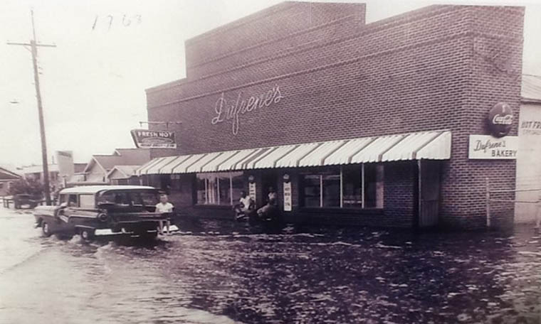
Perhaps the most famous business in Golden Meadow was Dufrene's Bakery (Fig. 2d; Schmidt 2010a). The bakery was opened in 1929 by Paul Dufrene, a baker from Thibodaux, La., who recognized the business value of the emerging population center in Golden Meadow. In addition to pastries, pies, and a diversity of other confections, the bakery would produce at its peak up to 15,000 loaves of bread per day, which were distributed by the Holsum Bread Company and served as far away as Alabama. Visitors from around the country from coast to coast remember Dufrene's Bakery. Just one block south of the high school on South Bayou Drive, the bakery regularly served students after dismissal, football players after practice, and townsfolk all day long. Each beach-going or fishing trip to Grand Isle was incomplete without a stop at Dufrene's. In addition to French, poboy, and cap bread, raw bread dough was also a delicacy, as it was taken home and fried or baked to be eaten sweet or savory. Their specialty French bread loaves, different from traditional French breads and baguettes, coupled a light, crispy crust surrounding "lighter-than-air" breadstuff, a unique recipe fulfilled by long-time bakers who specially controlled the leavening process.
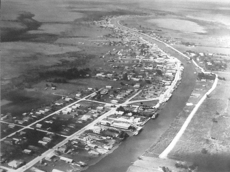
Although settlement inaugurated on the east bank of Bayou Lafourche near the present-day Yankee Canal, Golden Meadow developed almost exclusively on the west bank of Bayou Lafourche (see Figs. 2 and 5). Schools and business are located there along LA 1, together with the majority of the town's population. Within the corporation limits, settlement along the east bank of the bayou along LA 308 remains largely pasture and is only sparsely residential. In the early days, private barges ferried folks between bayou banks, the most heavily used was between the part of town known as Pointeau-Saucisse42 and the high school. This was the spot where the first mechanical bridge was built. The pontoon bridge was often in disrepair due to the large volume of water traffic, particularly large boats and barges connected to the drilling industry and particularly during trawling season. It was replaced in the 1970s by a steel lift bridge that today shows age and proximity to the brackish environment.
As low-lying land, Golden Meadow has been susceptible to flooding from its beginnings. Circumstantial evidence (see Note 13) suggests that the tidal surge from 1915 storm reached town, some 20 miles inland. But it wasn't only hurricanes that flooded town: both heavy rains and high tides from the south would commonly push water over parts of South Bayou Drive (see Fig. 2d). In 1970-71, the town installed a concrete seawall along LA 1 to help keep floods away from residences. The 3-foot tall seawall runs between the bayou bulkhead and the highway and is anchored at the north and south corporation limits by elevation of the highway. In addition, a ring levee surround the 10th Ward of Lafourche Parish (Larose, Cut Off, Galliano, and Golden Meadow) was completed in 1981 with terminal flood gates in Larose at the Intracoastal Canal and south of Golden Meadow. Locks internal to the flood walls have now been added.
Finally, Some Prehistory
Always cognizant of their place in history and environment, townsfolk were proud to refer to the quiet bayou that crossed their front porch view as "the old Mississippi River." At the time of early settlement, Golden Meadow was the site of a large grove of moss-covered oak trees rising from the banks and prairie established long ago as silts deposited by Mississippi flood waters rose and ebbed to create the land of the Lafourche basin.
Over the course of about 7500 years, the lower reaches of the Mississippi River changed direction, building and abandoning a sequence of deltas that resulted in much of the land of modern-day southern Louisiana. Bayou Lafourche was one of these delta-building river trajectories and served as the major path of the river for over a century. In the waning years of building the St. Bernard delta (4000-2000 years ago), the river redirected west, forming a new stream beginning around present-day Donaldsonville over a valley formed by drainage of the North American glacial ice sheet about 80,000-11,000 years ago. With that event, the Lafourche delta began to form, beginning about 2500 years ago and continuing for another 2000 years. It would create the all land we now know as Lafourche Parish,43 as well as parts of Ascension, Assumption, and Terrebonne Parishes. The Lafourche "river" was abandoned about 500 years ago during formation of the modern-day Plaquemines-Balize Delta, eventually creating what we now know as the current mouth of the River (Blum and Roberts 2012).
Today, the center of Golden Meadow lies about 80 miles from the origin of the bayou at Donaldsonville and about 21 miles from the mouth of the bayou at Port Fourchon (see Note 24), where it meets the Gulf of Mexico. Before the era of canal building, the bayou was the single outlet to the Gulf for explorers, settlers, and early fishing and oil exploration industries. The oaken ridge at the heart of Golden Meadow was a convenient landing.
The Modern Gateway
As with all things, change happens over time—towns and economies included. Golden Meadow has certainly changed over the past century. With a population peak in the early 1960s at 3000 persons, current town records indicate the population today is just above 2100. Certainly, downturns in both fisheries and oil exploration due to changing abundances and governmental restrictions, together with improvements in industrial technologies, have led to diminished job availability and consequently a reduction in population. As well, those who remain working in those industries can count on better, more efficient transportation and can thus afford to live father upstream. Small, locally owned businesses like food and merchandise stores, banks, and restaurants gave given way to larger enterprises, like box stores, corporate banks, and other food service operations—some with delivery and online services—all located out of town.
Though incorporation of the village did wonders for its growth after 1950—providing police protection, waste disposal, streets maintenance, tractors and truck service, and mosquito control, among other amenities—it ultimately restricted the town's growth to the three square miles within the corporation limits. Modern businesses, particularly ones requiring large footprints, formed outside of town upstream in Galliano, Cut Off, and Larose. Residents desiring more property, newer homes, more distance from neighbors, and quicker access to larger shopping centers also settled upstream and out of town. A new, four-lane highway, LA 3235 (see Fig. 2), was built to the west of town outside the reach of most residential streets primarily to serve as a rapid hurricane evacuation route for the people of Golden Meadow and the 10th Ward. Consequently, it also served as a new avenue for business, and many businesses left bayouside Golden Meadow in pursuit of more land and more drive-by traffic, as well as escape from local corporation taxes.
Although they may not all face the bayou and have storefront docks as in the early days, modern-day Golden Meadow still offers industrial services, food services, and local restaurants, on both LA 1 and LA 3235. It remains a dense, largely residential area that watches recreational boats traverse the bayou en route to fishing and vacation camps in the marsh, at Cheniere, at Fourchon, and Grand Isle. Though no seafood processing factories remain, the town retains a small seafood fleet and one trawl board and net shop. The largest area of growth is to the south of town, where large landform docks have been created on the bayouside of LA 1 for ships serving Gulf industries. These operations are built just inside the ring levee and are protected from hurricanes and high tides. As they traverse Golden Meadow, LA 1 and Bayou Lafourche remain the gateway for equipment and supplies to reach Port Fourchon, the largest deepwater seaport on the Louisiana coast, the land base for the Louisiana Offshore Oil Platform (LOOP), and provider of services to 90 percent of the Gulf of Mexico's deepwater oil production (see note 24).
Conclusion
In many ways, Golden Meadow served as the oasis of rural southern Lafourche Parish. In terms of residence, business, and service to two of Louisiana's major industries, Golden Meadow was a major hub of activity through the 1960s and 1970s before industrial declines and the migration of businesses upstream. Today, it remains largely residential with a healthy focus on mitigation not only of land loss but also of historical knowledge and cultural heritage concomitant with loss of population. For many, it served not only as home but also as a place of great economic opportunity to rise from humble settler beginnings. As well, it became an incubator for unique cultural development as its ancestry migrated from prairie to marshland to coast and back and its economy transitioned from farming to fishing to drilling and to oil field services.
Perhaps the opportunity afforded by this small town in southeastern coastal Louisiana can be summed up by the life of my relative Jefferson Rebstock (Davis 1960). Jefferson was the grandson of John Rebstock, the once orphaned oysterman of Cheniere Caminada and progenitor of the extended Rebstock family of Golden Meadow that includes my mother. Jefferson's father was born on Cheniere Caminada and survived the 1893 storm. After attending college, Jefferson returned in 1914 to manage his father's mercantile store, which had moved from Leeville to Golden Meadow just before the great storm of 1915. He subsequently became employed in one of the first banks in town. During this time, he was also engaged with his father in the Lafourche Packing Company, a shrimp processing operation. Between 1922 and 1965, he built, operated, and managed entertainment at a motion picture house in town called Rebstock Theater. He organized the Gulf Coast Shrimp Company, the first enterprise to freeze shrimp and one of the largest canneries in the nation. With the discovery of oil on family property at both Leeville and Golden Meadow, he established multiple drilling companies specializing in shallow inland waters of Louisiana. He also served as director of a wealth management firm in St. Louis, Missouri. A descendant of the triumvirate of storms and deeply involved in leadership of the two major industries of the Golden Meadow as well as other business ventures in the town, Jefferson represents all the opportunities afforded by living in the boom days at the gateway to the Gulf.
The author acknowledges conversations with Chef Randolph "Randy" Cheramie of the John Folse Culinary Institute at Nicholls, Windell Curole of the South Lafourche Levee District in Galliano, La., and archivist Clifton Theriot of the Ellender Memorial Library at Nicholls, as informative to the preparation of this article.
Notes
1. Several aspects of this property and house are worth mention, as they are common to many homes in Golden Meadow and neighboring villages. The down-sloping roof at the house front functioned to slow and direct rainfall, which is common year-long in this sub-tropical climate. The front porch facilitates leisure time watching townsfolk cross the sidewalk to the fore of the property, as well as highway and bayou water traffic. Screening functions to keep mosquitoes, gnats, and other biting flies away from porch dwellers but permits the salty breezes from the Gulf to pass through. Narrowness functions to accommodate as many land owners as possible in the early days before adequate drainage, as the bayoufront land—the natural levee of the bayou—was higher elevation and thus more resistant to flooding from the bayou during southerlies or heavy rainfall. The lower, marshier back property was commonly used for farming and raising animals. Raising the structure on house piers or cinder blacks protected it from flooding. Powdery white was a color commonly used for the homes of fishermen (and was also the color of their boats); in fact, a village north of town on LA 1 is named Côte Blanche for this reason.
2. Although the origin of this epithet is unknown, it may derive from as early as the 1896 awarding by the Postmaster General to Lafourche Parish one of the first Rural Free Delivery services in the U.S. (Borne 1944). "Longest Street" has variously referred to Lafourche Parish, the Tenth Ward of Lafourche Parish, and the entire length of LA 1 from the northwestern state line through Lafourche Parish to the highway's end on the coast at Grand Isle.
3. The 10th Ward is an administrative subdivision of the parish that includes the sequence of residential areas commonly called "South Lafourche." Town areas in this Ward are Larose, Cut-Off, Galliano, and Golden Meadow.
4. Colloquial French-speaking townsfolk referred to the sidewalk as "the banquette" and sometimes pronounced the word with emphasis on the first syllable, as in "bank-it."
5. My parents' home was one street away from Williams Road, where in Williams Cemetery is the tomb of one of the town's first settlers, William Riley Williams.
6. It is also claimed by some that Hank Williams coined the line "my cher-a-mio" in his hit song "Jambalaya" from a visit to Golden Meadow where he learned of the Cheramie family name. Some townfolk say, too, that his "Sweet Yvonne" from the same song was a resident of town.
7. This may have been Edward Wisner, the "Father of Reclamation" (Wisner 1918), who inspired and produced major reclamation projects across Louisiana after 1900. He was a native of Michigan and came to Louisiana at the turn of the twentieth century. At one point, he held 1.5 million acres of swamp and marshland across southern Louisiana (Harrison and Kollimorgen 1947a and 1947b); the modern-day Foundation bearing his name still owns and leases major acreage of swamp and marshland across southern Louisiana. Wisner was associated with J.M. Dresser, who not only was vice-president of Wisner's first land company, the North Louisiana Land Company (registered with the Louisiana Secretary of State in 1900) but also vice president of the Golden Meadow Development Company (of New Orleans, registered in 1905, with W. H. Junk of Dixon, IL, as president). It was this latter company that not only reclaimed marshland east of Bayou Lafourche for rice farming but also developed the drainage canal that became known as Yankee Canal, which gave the original settlement its name. (See News and Notables 1902 and 1903). Although the project was eventually abandoned, the remnants of reclaimed farm plots from this development can still be seen in satellite images.
8. Townsfolk insist that "Golden Meadows" (plural) was original, and as French speakers often drop terminal pluralization persistence of the singular "Golden Meadow" is logically explained. The plural may have also been inspired by Wisner's umbrella company, "Louisiana Meadows Company" (of New Orleans, registered 1908; see Harrison and Kollmorgen 1947a and 1947b), which carries the plural. However, the Golden Meadow Development Company (singular) predates that company's registration by three years and is the first and most logical origin of the settlement's eventual name. To confuse things further, the successor to the Development company, the "Louisiana Golden Meadows Land Company," registered in Lansing Michigan in 1911, carried the plural as well. (See American Sugar Industry). Regarding the figurativeness of the village name, Rome's account (1996) describes two long-held explanations, one pertaining to the promise of "golden yields" of the town's lush farmland and oil fields (though oil was not discovered there until 1938) and the other pertaining to the vast growth of yellow wildflowers in the low marsh prairies. These flowers are often mistakenly referred to as goldenrods but are actually Pakera glabella, the common butterweed, which is native to Louisiana and the Gulf South. Though considered vulgar, townsfolk have historically called these wildflowers pis-en-lits, which is an epithet common in France for the dandelion plant (which also make yellow flowers). The diuretic property of brewed dandelion leaves is long known on both sides of the Atlantic. How early settlers of Golden Meadow appropriated this name is not certain, but a plausible explanation is transmission along generations from Acadians of the 1785 migration to Lafourche. Upon expulsion from maritime Canada in 1755, the Lafourche Acadians were temporarily repatriated to France for only 30 years, and after they arrived to Bayou Lafourche in Summer and Winter of 1785, they may have readily recognized early the following Spring large swaths of butterweed growing in low areas and along the bayou levee, borrowing the dandelion epithet remembered from recent residence in France to describe them. Louisiana reclamation companies at the turn of the 20th century were also deeply involved in promoting potential reclamation lands to both investors and settlers. Combining the image of yellow wildflower lowlands and associating it with his company's name may have led to the attractive term, "golden meadow(s)," from which the town's name derived and persisted.
9. As example, Joseph Celestin Doucet, the grandson of one of the original 1785 Acadian settlers in Lafourche, Jean-Baptiste Doucet, was already a fisherman at Cheniere Caminada in the 1850 U.S. Census—only three generations from farming on a Spanish territorial government land grant to fishing at the coast.
10. The name of modern-day Golden Meadow's recreational area, Oakridge Community Park, as well as a subdivision, Ridgefield Blvd., represent this history and geology.
11. Variously known as L'ouragan de la Chênière Caminada and the Great October Storm of 1893, this storm, estimated to be a Category 4 event on the modern Saffir-Simpson scale, struck Cheniere Caminada without warning and overnight on 1-2 October, killing an estimated 2000 persons in its path and destroying the village's homes and fishing fleet. Today, the village site, on the mainland peninsula just northwest of Grand Isle, La., is represented by a historical cemetery and a collection of modern fishing camps. A major supplier to the New Orleans markets in its day, Cheniere Caminada is likely the largest coastal fishing village in Louisiana history.
12. Chenieres are prehistoric shorelines that form progressively toward the Gulf over time as Mississippi River silts are driven west and remodeled by prevailing coastal currents. Found on all continents in or near river deltas, the name of these geological structures (which means "oak grove" because at 2-6 feet above sea level they support the growth of oak trees above the Gulf saltwater) is uniquely Cajun, deriving from the French of southwestern Louisiana where they were first described (Russel and Howe 1935). To the east of the Fourchon, where Bayou Lafourche meets the Gulf, chenieres formed angularly and accreted to an eastern point just north of the western aspect of Grand Isle. The easternmost point of this cheniere fan is an accretion of many such prehistoric shorelines that together produce a continuous and raised prairie plain. Due to both elevation as well as near vicinity to both trawling waters and coastal oyster reefs, the fan was an excellent location for the establishment of a coastal fishing village like Cheniere Caminada.
13. In "Oral Accounts of the Storms of 1893 and 1915 from the Cheniere Caminada Area," Patricia Perrin describes the account of how Levy Collins' new house at Leeville was carried by storm waters upstream to land at Golden Meadow. Seeing it as an act of God, several Leeville residents subsequently resettled in Golden Meadow (Perrin 1976-80).
14. Surviving families from this storm also relocated across the Gulf Coast, notably north across Barataria Bay in Salaville (modernday Westwego) and up Bayou Lafourche to found Côte Blanche (modern-day Cut Off).
15. The first such motorized boat in Louisiana is enshrined on the bayouside along LA 1 in Golden Meadow. The Petite Caporal, named with the epithet of Napoleon Bonaparte, was owned by early settler Leon Theriot, who in 1902 installed a three horsepower tractor engine in its wooden hull, effectively subverting the sail and rapidly rendering sailing fleet obsolete (Seigrist 1998).
16. These storms are known to locals as the Leeville Storm of 1909 (Category 3) and the Great Leeville Storm of 1915 (Category 4). For technical details of these storms, as well as the 1893 hurricane, see History of Hurricane Occurrences 1972.
17. This brief article from the Times-Picayune of July 23, 1916 also describes the first "Blessing of the Fleet" in Golden Meadow: "The bishop was requested to bless the boats owned by these fishermen, and while the large number present knelt on the shore, the bishop ... sprinkled the craft with holy water, and invoked a blessing on them and their owners."
18. Locals used the rather uninventive term "Texien" when referring to Texans or, in general, any out-of-towners. One the other hand, Texans used the vulgar term "coon-ass" to refer to locals. The origin of the latter term is widely disputed. (See Bernard 2003.)
19. For modern data that represents the historical situation, see "Golden Meadow, LA Population and Races," at www.usa.com/golden-meadow-la-population-and-races.htm.
20. For an excellent modern accounting, see Acadian-Cajun Genealogy and History by Tim Hebert (1997-2010), at acadiancajun.com/7ships.htm.
21. An illustration of the remains of Rebstock's home appears on the front page of the Weekly Times-Democrat (New Orleans), October 13, 1893.
22. While each of my parents were first of their families to be born in Golden Meadow, I am last, as my children were born in New Orleans while I attended graduate school and my wife served as teacher in New Orleans Public Schools. Officially, however, I was born at Lady of the Sea General Hospital located in the adjacent village of Galliano, La.
23. One hundred years following landfall of this storm, a grassroots organization of Cheniere descendants recognizing the impact of the storm—the Cheniere Hurricane Centennial—memorialized the 1893 disaster and celebrated the progress of the storm's survivors with a cultural festival on October 1-3, 1993. Events included story-telling, displays of traditional cooking and trawl net making, as well as other folkways. A feature of the festival was an original stage play based on historical narratives, Tant que Durera la Terre, written by the author of this article, which received the Louisiana Native Voices and Visions Playwriting Award in 1996.
24. At the end of the 17th century, French explorer Iberville first recognized a "fork" in the Mississippi River near present-day Donaldsonville and named it La Fourche. Appropriately, the terminus of Bayou Lafourche as it reaches the Gulf is named Fourchon, the French word that refers to a fork's tine. Some bayou folk believe that the bayou was named for this coastal terminus, as the bayou "forks" into Belle Pass and Pass Fourchon before reaching the Gulf, but this explanation is not historical and is a recent misappropriation. Between Belle Pass and Pass Fourchon today is a significant seaport—Port Fourchon—that services 90% of the Gulf's deepwater oil production (See portfourchon.com.)
25. For an excellent but small treatise on this craft, see Butler 1985.
26. The Golden Meadow (Oil and Gas) Field was a broad series of wells drilled in the shallows surrounding a salt dome underlying the Golden Meadow prairie. Severe channelization of the western marsh provided access to prime drilling sites but also resulted years later in saltwater intrusion, marsh loss, and subsidence. The natural gas wells ultimately provided the town through its municipal utility company with low-cost natural gas to heat and power homes and businesses.
27. The botruc (from "boat" + pickup "truck") was conceived in 1956 by Cheramie Brothers, Inc., based on the design of large water ferries in New England with forward deckhouses and broad, open afterdecks to carry cars. In the case of the botruc, the large rear deck was used to carry supplies for offshore drilling. Botrucs were large, ocean-going vessels of increasing size. (See Fig. 3c and d) The original Cheramie Botruc No. 1 had a 65-foot hull, and the more modern Cheramie Botruc No. 40 has a hull 235 feet in length. For a history, see Falgoux 2017.
28. The bayou was dammed to prevent seasonal flooding, a particular nuisance to the farming enterprises of Ascension, Assumption, and upper Lafourche Parishes. Damming was designed to be temporary until a system of locks to regulate flow down the bayou was constructed, but these locks were never built. In effect, the bayou became a stillwater, depriving the lower marshes of building sediments and nutrients and permitting the intrusion of environmentally destructive saltwater from the Gulf. After a century, the effects of damming are seen as saltwater intrusion, severe deterioration and erosion of the coastal marshes, increased flooding from the Gulf during storms and high tides, and arguably the fastest rate of land loss in the world. Earlier in 2019, Louisiana's Coastal Protection and Restoration Authority (CPRA) approved funding to increase the capacity of river-to-bayou pumps over the levee at Donaldsonville in an effort to increase the flow of freshwater down Bayou Lafourche to stem saltwater intrusion and mitigate marshland loss.
29. This road, like others in southern Louisiana, was likely shelled and not graveled, using shells of the march clam, Rangia cuneata, which grow to enormous populations in coastal marshes of Louisiana and is the traditional material for roadbed construction (LaSalle and de la Cruz 1985). Travelers from the unpaved period recall the clouds of white dust kicked up by driving this and similarly shelled roads. The distinctive white surface of sun-blanched shells is easily recognized in period photographs (See Fig. 4).
30. Prior to the Louisiana Highway Renumbering Act of 1955, LA 1 in Golden Meadow had two designations: LA 622 north to the village of Cut Off and LA 620 south and then east to the Jefferson Parish Line on the outskirts of Cheniere Caminada and Grand Isle.
31. Beginning in the mid-19th century, the Sanborn Map Company published detailed line drawings of 12,000 towns and cities across the U.S. in an effort to assess local fire insurance liability (Sanborn 1922).
32. Shrimp drying was appropriated from Chinese and Filipino fishermen who settled in coastal Louisiana, some at Cheniere Caminada. Fresh shrimp was spread across a large wooden platform for desiccation in sun and open air. Once dry, workers would shuffle their feet across the shrimp to fracture and remove their shells, which would typically fall through the cracks in the planks of the platform. Unshelled dried shrimp were packaged and sold in an early 20th century industry. See "The Forgotten Story of Louisiana's Dried Shrimp Industry" at www.ultoday.com/node/2560.
33. As evidence of the prevalence of private oyster consumption in the middle of the 20th century, on a trip through neighboring Terrebonne Parish, Nobel laureate and author of The Grapes of Wrath John Steinbeck called bayou residents "shell-heap Cajuns" for the casual outdoor evidence of their shellfish meals. The reference can be found in his book, Travels with Charlie. As evidence of the prevalence of private shrimp and crab consumption in Golden Meadow, historical LA 1 travelers sometimes referred to town as "the place you can smell before you get there."
34. Delta Farms is a large land reclamation project begun in 1904- 05. It remains flooded after the 1971 levee breach and is visible on maps and satellite images as an unusually rectangular lake in the decidedly non-rectangular prairies east of Larose.
35. Likely a corruption of "Doucet," as this is the street on which my paternal grandfather and his extended family lived, including the first home of my parents. With historically heavy French accents in an English-hearing world, our family name has suffered multiple false inscriptions. In one of the disembarkment lists for L'amitie in New Orleans in 1785, my Acadian ancestors are labeled "Toussaint," which only roughly shares phonetics with pronunciation of "Doucet."
36. This change of church parish name is significant in the lore of town. Many townsfolk, themselves refugees of the triumvirate of storms, maintain that the name was changed to "prompt succor" ("fast relief") in an appeal for heavenly assistance in the aftermath of inevitable storms—most recently that of 1915, which was fresh in their memory. Although Pius XI declared Our Lady of Prompt Succor as the Patroness of the Archdiocese of New Orleans and all of Louisiana, this declaration happened in 1928, a full ten years following the name change at Golden Meadow, supporting the notion that local effort and recent history were imperatives for this change.
37. My great grandfather Celestin Doucet was also at one time buried here. But after one of the seasonal town floods when she couldn't reach his tomb, Celestin's wife Lezima moved his casket and reinterred him at Cheramie Cemetery, a non-church property some four miles north and two feet higher on the opposite of the bayou along LA 308. His father, Adam Octave, is also buried there.
38. Over these changes, the school has maintained cultural identity with its landscape. The school yearbook was originally called Le Derrick as homage to the oil drilling industry where young men would find ample employment opportunities, frequently causing them to stop-out before graduation. The yearbook was later renamed, The Lion, after the school's original and only sports mascot. Though "lion" is an appropriately fierce mascot, it is not culturally representative; the first line of the school's long-time fight song, however, clarifies this situation geographically: "We are the lions from the bayou land! / We're here to make you understand / We're on our way to victory, / and we won't be denied a score!"
39. During this period of time, members of this group were sometimes referred to as "Sabines" or Sabine Indians. The origin of this now abandoned term is unknown, and outside of academic studies the term was often used in a derogatory and derisive fashion. For a historical treatment, see Parenton (1950).
40. Fala (also known as "Faleau") may have formed after the 1915 hurricane, as it does not appear in the list of Houma villages in Swanton (1911).
41. My particular favorite was a platter of diverse local seafood broiled in butter and wine. On one visit, my mother ordered crab patties (boulettes) and was mistakenly served stuffed crabs in the shell. When I offered to get her plate returned, she resisted, saying, "Mais, that's all the same good inside, that!"
42. According to town lore, "the Pointe," located just upstream of Yankee Canal, was so named because the only cut of meat affordable from the visiting meat truck to the poor residents was the sausage made from the ground scraps of regular cuts.
43. Progressive river building was evidenced by a recent excavation in the prairie of southwest Thibodaux, where a layer of marsh clam shells (Rangia cuneata) was revealed 25 feet beneath peat and cypress tree remains. As these shellfish are known to occupy deltaic marshes, this indicates that the area of Thibodaux was at one point in prehistory a coastal marsh.
Sources
Alperin, Lynn M. 1983. History of the Gulf Intracoastal Waterway. Navigational History NWS-83-9. National Waterways Study. U.S. Army Corps of Engineers.
The American Sugar Industry and Beet Gazette XIII (3):117 (March 1911)
Bernard, Shane K. 2003. The Cajuns: Americanization of a People, Jackson, MS: University Press of Mississippi.
Blum, Michael D. and Roberts, Harry H. 2012. The Mississippi Delta Region: Past, Present, and Future. Annual Review of Earth and Planetary Sciences 40(655):655-83.
Borne, Leon A. 1944. The Longest Street in the World: A History of Lafourche. Lafourche Parish, La.: Police Jury of Lafourche Parish.
Butler Jr., Joseph T. 1985. The Lafitte Skiff: Workboat of the Bayou Country. Thibodaux, La.: Nicholls State University.
Chapin, Bobie T. 1962. World's "Longest Main Street." Landscape Architecture 52 (3): p. 152.
Cheramie Jr., Randolph. 2010. Randolph's Restaurant. In Lafourche Country III: Animals and Onwardness, ed. John P. Doucet and Stephen S. Michot, pp. 284-289. Thibodaux, La.: Lafourche Heritage Society.
Davis, Edwin A. 1960. Jefferson Joseph Rebstock. In The Story of Louisiana, pp. 199-201. New Orleans: J. F. Hyer Publishing Co.
Ditto, Tanya. 1980. The Longest Street: A History of Lafourche Parish and Grand Isle. Baton Rouge, LA: Moran Publishing Co.
Falgoux, Woody. 2017. Rise of the Cajun Mariners: The Race for Big Oil. New York: Skyhorse Publishing.
Golden Meadow High School. 2019. https://en.m.wikipedia.org /wiki/Golden_Meadow_High_School
Harrison, Robert W. and Kollmorgen, Walter M. 1947a. Drainage Reclamation in the Coastal Marshlands of the Mississippi River Delta. Louisiana Historical Quarterly 30(2):654-709.
Harrison, Robert W. and Kollmorgen, Walter M. 1947b. Past and Prospective Drainage Reclamations in the Coastal Marshlands of the Mississippi River Delta. Journal of Land & Public Utility Economics 23(3):297-320.
History of Hurricane Occurrences. 1972. New Orleans, LA.: U.S. Army Corps of Engineers.
James, Eloria N. 2001. Though Population Dips, Town Still Strong. Daily Comet [Lafourche Parish, La.] June 21: D5.
LaSalle, Mark W. and de la Cruz, Armando A. 1985. Common Rangia. U.S. Fish and Wildlife Service Biological Report 82(11).
Louisiana: A Guide to the State, pp. 217-585. New York: Hastings House. 1941.
Looper, Robert B., Doucet, John, and Charpentier, Colley. 1993. The Cheniere Caminada Story. Thibodaux, La.: Blue Heron Press.
Mumphrey, Anthony J. and Wagner, Fredrick W. 1976. The Impacts of Outer Continental Shelf Development on Lafourche Parish. Baton Rouge, La.: Louisiana State Planning Office.
New Parish Founded at Golden Meadow in 1916. Times Picayune [New Orleans, La.], July 23, 1916: A9.
News and Notables at the New Orleans Hotels. Times Picayune [New Orleans, La.], April 27, 1903: 3.
News and Notables at the New Orleans Hotels. Times Picayune [New Orleans, La.], November 16, 1902: 36.
Our Lady of Prompt Succor: Parish Centennial, 1916-2016. Princeton, NJ: Entourage Yearbooks, 1916.
Padgett, Herbert R. 1969. Physical and Cultural Associations on the Louisiana Coast. Annals of the Association of American Geographers 59(3):481-93.
Parenton, Vernon J. and Pellegrin, Ronald J. 1950. The "Sabines": A Study of Racial Hybrids in a Louisiana Coastal Parish. Social Forces 29(2): 148-54.
Perrin, Patricia F. 1976-80. Oral Accounts of the Storms of 1893 and 1915 from the Cheniere Caminada Area. Louisiana Folklore Miscellany IV:54-59.
Rome, Jeanne. 1996. A History of Golden Meadow. In Lafourche Country II: The Heritage and Its Keepers, ed. Stephen S. Michot and John P. Doucet, pp. 71-74. Thibodaux, La.: Lafourche Heritage Society.
Russel, Richard J. and Howe, Henry V. 1935. Cheniers of Southwest Louisiana. Geographical Review. 25 (3): 449-461.
Sanborn Fire Insurance Map from Golden Meadow, Lafourche Parish, Louisiana. Sanborn Map Company, June 1922.
Schmidt, Katherine. 2010a. Golden Meadow Bakery Remembered for Good Taste. Houma Today [Houma, La.], November 23.
Schmidt, Katherine. 2010b. Randolph's was a South Lafourche Landmark. Daily Comet [Lafourche Parish, La.], December 29.
Siegrist, Todd. 1998. Preserving History. Daily Comet [Lafourche Parish, La.], March 16: A5.
Swanton, John. J. 1911. Indian Tribes of the Lower Mississippi Valley and Adjacent Coast of the Gulf of Mexico. Washington, D.C.: Government Printing Office.
West, Robert. W. 1966. An Atlas of Louisiana Surnames of French and Spanish Origins. Baton Rouge, La.: Louisiana State University Press.
Westerman, Audrey B. 1995. First Land Owners and Annotated Census of Lafourche Interior Parish (Lafourche and Terrebonne). Houma, La: Terrebonne Genealogical Society.
Wisner, G. Franklin. 1918. The Wisners in America and Their Kindred: A Genealogical and Biographical History. Baltimore, Md.: G. Franklin Wisner.
Yoes, Gene. 1954. Lafourche Contributes to Louisiana History. Louisiana Police Jury Review 45-51.
