


Western Louisiana's Neutral Strip: Its History, People, And Legends
By Keagan LeJeune

Introduction
While some may lump the culture of the very western portion of Louisiana—south of Natchitoches and north of Lake Charles—into the general culture of North Louisiana, others identify it as a separate folk region. Known as Louisiana's Neutral Strip, the region once separated Spanish Texas from French Louisiana and is now home to a distinct culture. Locals, for one, are quick to proclaim themselves as residents of Louisiana's Neutral Strip or No Man's Land. In addition, folklorists, historians, and other scholars identify the region as culturally distinct and possessing many folk groups and traditions that set it apart from its neighboring regions. Slow to be settled and marked by a pivotal moment in history, the Neutral Strip region exhibits a culture colored by several pockets of diverse folk groups—like American Indians, remnants of early Spanish colonies, Scots-Irish pioneers, African Americans, and others—who fiercely hold on to their traditions and notions of identity. Sometimes described as a place filled with an outlaw culture or as a region with a reputation for a tough and isolated place, the region is better understood as bastion for those cultural groups who wished to find a home where they could preserve a way of life they cherished. Understanding this region involves first understanding its history and then understanding the people and the lore that this history has shaped.
History
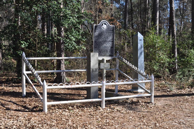
The Neutral Strip region draws its name from the area's brief stint as an official buffer zone between Spain and the United States following the Louisiana Purchase. When the United States purchased the territory from France, Spain and the U.S. argued over the boundary south of Natchitoches. In part, this confusion derived from the region's long history, even before Spanish rule during the 1790s and 1800s, as a contested area with unclear boundaries. Moreover, to a large degree Spain governed the region with a blind eye, allowing squatters and all manner of self-directed settlers, such as American Indians who lost lands during the French-Indian War, to settle there in order to thwart American expansion (Haggard 1945: 1002-1004, 1019, 1021-1023). In lieu of an armed clash to decide the new territory's borders, both governments agreed to remove all troops from the disputed area until boundaries could be determined, and the official Neutral Strip was born. The region's use as an official buffer between Louisiana and Spanish Texas lasted roughly from 1806 until the 1819 Adams-Onis Treaty that established the Sabine River as the territory's western boundary.
However, the agreement led to unintended consequences. While diplomatic negotiations moved laboriously forward, squatters, fugitive slaves, filibusters, smugglers, and even outlaws used the Neutral Ground as a safe haven. Soon the region became known as a no man's land where residents in the region often faced criminals alone and without governmental aid. One victim of the area's bandits in a petition to the U.S government explained that "the damned Neutral Ground is cursed of the Devil" and had been overrun with bands of desperate men (Haggard 1945: 1064).
This brief period of lawlessness and isolationism that the Neutral Strip experienced ingrained in residents a deep sense of self-reliance and autonomy. Due to the region's isolation and due to its place as a border and buffer zone, the region's residents possess a strong sense of self-sufficiency. The lack of troops in the region during its role as an official buffer only intensified these sensibilities, and early residents of the Neutral Strip often relied on family members and friendly neighbors for protection and survival, forming an extended network of partnership. Through the years, patches of residents (often related to each other) banded together to provide their small communities with schoolhouses, churches, and even a means of self-rule and self-defense. For decades no outside system could unseat this rule of family and clan.
Overview
While determining exact boundaries of the region is difficult, historian J. V. Haggard defines the region as the area lying east of the Sabine River and lying west of the Calcasieu River, Kisatchie Bayou, and Arroyo Hondo. In its official historical form, the region stretched south until the Gulf of Mexico and north until the 32nd parallel of north latitude, which runs near Natchitoches. However, as a cultural region the southern boundary appears to be Highway 190 and the northern boundary to be Logansport, Louisiana. The Neutral Strip region encompasses the current parishes of Desoto, Sabine, Vernon, Beauregard, the northern portions of Calcasieu, and the western portion of Allen.
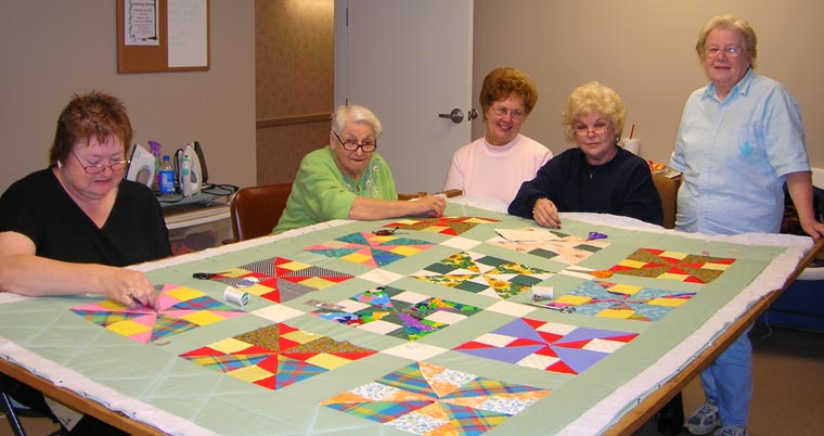
In some regards the Neutral Strip shares cultural practices with its neighboring regions. The Upland South hill culture that dominates much of North Louisiana stretches across the uppermost portions of the Neutral Strip and endows the region with typical cultural traits of those settlers. A significant number of pioneers in No Man's Land were Upland South people of Scots-Irish descent. These small subsistence farmers practiced an evangelical and fundamental Protestantism. They held, as scholars explain, a Scotch-Irish ethos and a "world view of identifying religion with character" (Roach 1986). As a result, traditional cultural practices of Upland South people, such as Anglo-American quilting, bluegrass gospel music, and foodways traditions relying on corn, peas, chicken, and pork can be found in the region (Owens 1997). The log culture one finds in other portions of Louisiana can also be found in a section of the Neutral Strip. This cultural background can be seen in the widespread use of dogtrot houses and log construction. The western portions of the region running along the Sabine River share traits with the East Texas Big Thicket pioneer culture across the river. For example, a few distinct traits of that East Texas culture are free-range stock raising employing specialized dogs and residents negotiating unfenced and thus nebulously owned portions of wooded property (Sitton and Hunt 2008: 3-4). One finds those features along the Sabine's Louisiana banks as well.
However, the region's time as a neutral buffer alters significant portions of its culture that make it distinct. First, the region's historical status during that time, though brief, not only serves as the region's namesake but also as a mental reference point for many of its residents. The Neutral Strip's population possesses a noteworthy sense of self-awareness. Many residents identify themselves as residents of Louisiana's No Man's Land, another name for the region, and much of its oral tradition connects to this particular historical moment. Second, the region's history also endowed it with aspects of Spanish colonial culture which mark it as distinct. Third, the region's position as a space between Spanish and French then American culture delayed settlement in the region and left it comparatively less populated and settled than northern and eastern portions of Louisiana, and even portions of Texas. As a result, several groups moved into the region and formed dense cultural islands in order to avoid assimilation by other groups and to maintain cultural identity through a strategy of separation. Fourth, Anglo-Americans migrating into the region after the Louisiana Purchase faced a challenging cultural landscape—one that was on the one hand sparsely populated and on the other dotted with these fiercely cohesive cultural pockets. This situation necessitated within the new settlers strong kinship ties and resulted in their forming close-knit communities, which often still persist throughout the region in some form or another. Locals sometimes describe this end result as a pervading clannishness that colors the region. Finally, having fought so fiercely to settle in the region and maintain and preserve their cultural identities, entrenched residents often possessed intense attachment to their home and powerful desires to protect it from perceived threats, so the region's lore is also marked by cultural clashes, both of a small and large scale.
Its Settlement and People
Settlement
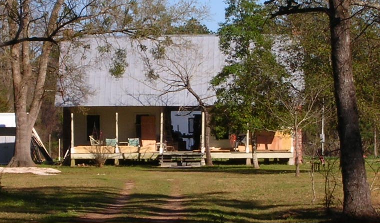
The geography of the Neutral Strip is marked by the Sabine River basin and the dense pine and hardwood forests that grow in the region. Flat slopes and wide timber floodplains comprise most of the Sabine River basin. The river begins in the rolling terrain of eastern Texas and central Louisiana and travels south to end in the mires and swamps of the Gulf Coast. Loblolly, longleaf, and shortleaf pine; red and white oak; black gum; and flowering dogwoods grow in the basin. Large cypress trees that once lined the river's banks also made the river a place of beauty and wealth. In fact, Sabine comes from the Spanish word for cypress, and in its early days, the Sabine was the lifeline of the region. The Sabine River furnished transportation for many early settlers and moved cargo in and out of the region. Small homespun facilities for processing lumber and cotton also dotted the banks. As timber production increased, great logs cut from the pine forests were lashed together to make rafts to be floated downstream.
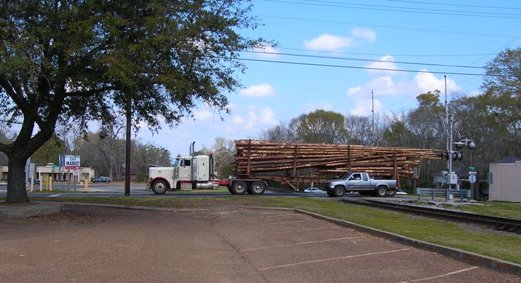
The northernmost portion of the Neutral Strip rests on the edge of Louisiana hill country. Most of this land, except the area running along the Sabine River, is drained by small creeks and bayous and fails to have the type of soil or water supply that can support a plantation-scale agricultural system. As a result, many of the early residents were small-scale farmers and used the forests—cutting crossties for railroads, shingles for local residents, or running small sawmills called peckerwood mills—as a means of earning cash.
Many early Anglo Neutral Strip settlers migrated to the region from Tennessee, Kentucky, Mississippi, and Arkansas after the Louisiana Purchase (Owens 1997). Most of these Upland South pioneers held strong religious convictions, embraced small farm life, and were rooted in family tradition. Living in sparse and scattered settlements, Upland South pioneers developed close relationships with neighbors who often shared the work of larger jobs, such as building a house or daubing a chimney. The pioneers coped with the harsh and often remote landscape by learning to adapt to the region's specific demands (Sitton and Hunt 2008: 10-11, 40; Smith 1999: 50-52). To overcome the difficulty of hunting in the thick pine, Upland South pioneers bred and trained one breed of dog (a cur) to corner wild boars in the brush and another (a deer hound) to run deer through the woods into the hands of waiting hunters.
Tied to the land by a mixture of subsistence farming, free-range hog or cattle running in the woods, hunting and fishing, and work in the woods, most Neutral Strip settlers were self-sufficient and accustomed to a rugged life. Like many Upland South pioneers, Neutral Strip settlers tended to settle on hilly or elevated ground—sometimes described by Neutral Strip residents as hummocks or hummock land or "hammocks." Those that did settle on lower land near the Sabine sometimes became ferrymen or specialized in transporting cargo down waterways. On occasion, this included specializing in marking and navigating rafts of cut logs to mills down the river.
Spanish Influence
One particular feature of the Neutral Strip is the lasting influence of the region's status as a Spanish colonial possession. Before the Louisiana Purchase and the arrival of Anglo-Scots-Irish settlers, Spain considered the region an important piece of its strategy to stem American expansion (Haggard 1945: 1018-1019). Ironically, this strategy primarily approached the region with two tactics emphasizing a detached Spanish rule. First, due to expense and difficulty of fortifying it, the region was left comparatively unprotected and unsupported by Spanish troops, which meant any would-be settlers faced an uninviting and dangerous landscape. Second, Spain encouraged several groups of Southern Indians to settle there if these groups promised to deter American expansion (Haggard 1945: 1010).
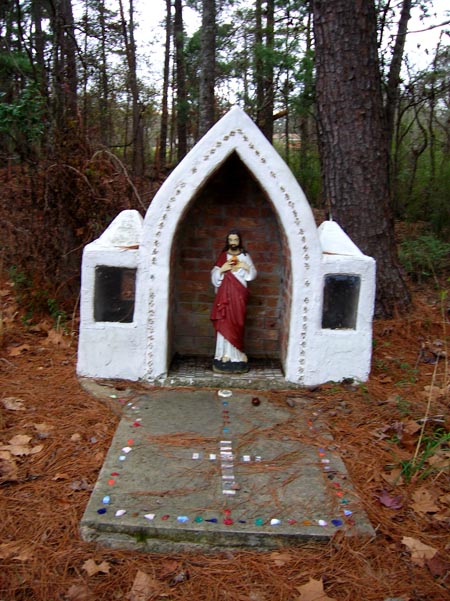
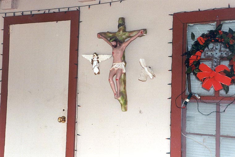
While settlers in the region included French, American Indians, African Americans, and Cajuns and the region's cultural traditions exhibit this diversity, a critical part of the region's character connects to this Spanish history. In Ebarb, Zwolle, Los Adaes, Robeline, Spanish Lake, and other areas in the Neutral Strip, colonial Spanish influence remains a part of the culture. Many residents of the Ebarb and Zwolle communities trace their ancestors to Spanish soldiers who manned the Los Adaes Presidio. When the presidio closed in 1773, these soldiers refused to return to interior Spanish possessions and founded these small communities in Louisiana. During the region's official status as a neutral buffer, a band of Choctaw moved into the region and "merged with the Ebarb community" (Lee 2013). Tamales and chilies still stand as traditional foods and as potent cultural symbols (Owens 1997) and scholars note that some residents still "speak a unique, archaic Spanish filled with Nahuatl Indian and French loanwords" (Armistead and Gregory, qtd. in Owens 1997). Spanish Catholicism is also evident in this portion of the region. Indo-Hispanic traditions remain strong in the contemporary community. As one scholar notes, "Wooden crosses and religious figures decorate houses inside and out, and rosaries with crosses carved from wood or antler on knotted twine are still made by a few elders (Lee 2013).
Some of the region's lore also connects to the Spanish influence over the region. Variants of La Llorona-"The Weeping Woman" or "The Woman in White" who is a ghostly woman wailing over the loss of her children because of the harm done to her by the man she loves—stand as one of many "rich folk narratives about murders, suicides, ghosts, and buried treasures" (Sepulvado 2004: 7). Circulating in the region, these stories connect not only to the area's stint as a No Man's Land but also to the Spanish and Hispanic cultural presence in the region. Popular in Zwolle, one La Llorona variant tells of a crying woman near San Miguel Creek, now covered by Toledo Bend Reservoir, who either committed suicide or was killed by "a mean man" who "killed several people" (Salter 1996: 28).
La Lorona is a widespread legend in Hispanic culture and indicative of the region's Spanish cultural features. In addition, one is also likely to hear of Spain's connection to the region through tales of lost Spanish mines spread throughout the Neutral Strip. In fact, Haggard points out that these rumors drew some of the earliest residents to the Neutral Strip (Haggard 1945: 1002-1003). Of course, one is also likely to hear stories about Spanish gold and silver that was lost along roads crisscrossing the region when Spain transported its wealth from its outer possessions, like New Orleans, back to the heart of New Spain. For instance, in DeRidder and Merryville, residents tell of a lost Spanish silver mine and a small tight-knit group of men who discovered it, disappeared into the woods periodically to return with bags of minted silver dollars, and kept the location of the stash a secret until each one of the men died.
Cultural Islands
The region's remoteness and long history as a border allowed for many groups to carry out a strategy that preserved cultural practices through isolation. Sometimes this isolation was simply the effect of the region's remoteness and sometimes it was quite intentional, as was the case with several Native American groups (Gregory 2004: 5-6).
To avoid contact with Europeans and avoid war, bands of Koasati or Coushatta, for instance, left their ancestral homes in Tennessee for Alabama, Georgia, Mississippi, Florida, Texas, and, of course, Louisiana. The last two significant populations are the Alabama-Coushatta Tribe living near Livingston, Texas, numbered at approximately 1,000 members, and the Coushatta Tribe of Louisiana numbered at approximately 900 members. As early as the 1780s, members of the Alabama and Coushatta tribes had settled in east Texas and west Louisiana, which was under Spanish control (Langley, Oubre, and Precht 2010: 26-27). Spain saw Louisiana as an important buffer between American settlements in the South and the prized lands of Texas and Mexico. Spain considered Indians as a useful tool in slowing American settlement and offered the Coushatta land.
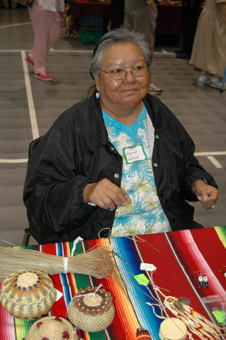
Since settling on the Red River in 1797, the Coushatta moved throughout eastern Texas and western Louisiana in an effort to avoid conflict with encroaching Americans. By 1861 at least 250 Coushatta migrated to the Calcasieu River. In the 1880s, a group of approximately 300 Coushatta settled at Bayou Blue (Langley, Oubre, and Precht 2010: 27). At Bayou Blue the Coushatta preserved a culture rich in traditional arts and crafts and preserved their ancestral language, which is still spoken by tribal members. The Coushatta pine needle basket exemplifies the Coushatta's close relationship with the local environment and their ability to employ natural resources for survival. Throughout its history, the Coushatta people have remained an intact and culturally unique group.
Like the Coushatta, several groups in the Neutral Strip clustered into these cultural islands in response to perceived threats (Davis 1971: 299). The region's availability of land and sparse population allowed for group members to settle close together and maintain a group identity in the face of surrounding dominant cultures. In a few locations in the southern portions of the Neutral Strip, several communities exist that see themselves as a distinct cultural group. Known as Redbones, though the word is often used as a pejorative, many explain the group as descendants of early British-American settlers from Tennessee and the Carolinas who migrated into the region and intermarried with American Indians populations already in the region (Kniffen, Gregory, and Stokes 1987: 92; Smith 1999: 71, 90-91). However, it's important to note that a great deal of debate exists about the group's origins and identity, even within members of the group itself. Some claim Rebones possess Spanish and/or Indian ancestry, (Orgera, Ryan and Wayne Parent 2014: n.p.) and some argue Redbones connect to Melungeons, tri-racial isolates in the Tennessee area (Marler 2003). Some members of one Redbone community trace the group's settlement to Father Joseph Willis, a Baptist preacher whose father was a British immigrant to Virgina and whose mother was an Indian slave. (Willis traveled to Louisiana in the early 1800s.) A few key settlements of Redbones exist in the region—near Starks, Elizabeth, Merryville, Pitkin, and a few other locations. Though very little research has been conducted about the group, Redbone communities and those communities surrounding them possess strong notions about the cultural practices of the group. Local lore suggests that through the course of their cultural history Redbones have felt pressured to defend themselves against encroachment and acculturation.
Once of the most famous stories in this region is the Westport Fight, a fight in 1882 between two sets of settlers—Redbones and Cajuns. In the late 1880s, entrenched residents of Louisiana's Neutral Strip suddenly experienced the arrival of settlers looking for land now open by governmental action. When inhabitants met brash new settlers eager to carve out their own way of life, established inhabitants and newcomers clashed.
According to several people, the Westport Fight was a battle over an imaginary boundary/settlement line drawn by Ten-Milers (called this because they lived near Ten-Mile Creek, which was about ten miles from Hineston, Louisiana) that had been crossed by infringing settlers. According to local lore, the fight began over the disputed results of a horse race between Henry Perkins, a Ten-Miler, and Buck Davis, a newcomer, (Crawford 1993) but others claim the Westport fight was the inevitable culmination of the animosity between the Ten Milers (many of whom were Redbones) and the new wave of settlers (many of whom were Cajuns). When Davis narrowly lost to Perkins, many people, including newcomer Gordon Musgrove, thought the decision was unfair and believed Davis should fight Perkins for cheating. Marion Perkins overheard Musgrove bragging and fought him for it. The fistfight ignited a powder keg. The newcomers barricaded inside the store and the entrenched residents gathered arms. Then, a shootout occurred. Not only were several people killed during the fight, but afterwards the small store was burned and several of the new settlers' farms were destroyed.
Neutral Strip Squatters
In part, the existence of these cultural islands is due to the squatting that took place in the region by many early settlers. While some early settlers held official grants or deeds to the land, many settlers in the region simply squatted on land that was unfenced (Sitton and Hunt 2008: 3-4). Even though these squatters held no "official" rights to the land, they held strong beliefs that a tract of land was theirs by right of having settled it and remaining on it for several generations. The various waves of settlement in the region and the unofficial nature of some of these settlements have endowed the region with a history of property disputes, so stories of fights and feuds fill the region's lore.
One story often told is the story of The Rawhide Fight, which occurred in the 1850s. Legend says the fight occurred over a schoolhouse in Walnut Hill, Louisiana, near present-day Leesville (Ford 1955). Legend says that the residents built the schoolhouse for people to attend school, but the building was mysteriously burned before it opened. When the community began to point to a certain suspect, the community split with one side defending the accused and one side wanting justice. To prevent violence, a community meeting was held at a local trading post to discuss how the community should proceed, but during the meeting, a fight broke out that left six people dead. The dead bodies were put on rawhides sold by the store, thus the fight became known as The Rawhide Fight. While some versions of the legend say a young man who didn't want to attend school burned the building down, other versions hint that the burning of the school and subsequent fight were more about disagreements over who would run the school and the outsiders who might attend it.
While squatters in the region often fenced their small gardens or patches of corn or peas surrounding their home, wooded grazing land was left unfenced. Cattle and hogs ranged free, which often caused disputes over stray animals and grazing rights. Feuds among families often were a means of negotiating property and grazing rights and regulating behavior (Hyde 2007). Large-scale feuds and small acts of justice consequently also have become part of local lore. Perhaps the most famous feud is the Conner feud involving the Conners, Smiths, and Lowes of Scrappin' Valley, and Scrappin' Valley is an area in the region known for violence. Even though this section is actually in Texas, it's often associated with The Neutral Strip. Settled in the 1800s by Conners, Weeks, Lowes, Fergusons, Smiths, and Easleys, the lack of law in the region required that locals set their own rules and enforce them on their own (Abernathy 2010). The fight began over grazing rights when two Conners killed men encroaching on a nearby wood that the Conners believed was theirs. The fighting escalated when Texas Rangers arrived to arrest the men. A massive shootout ensued and four Texas Rangers were killed. While listeners may find them strange or perhaps more befitting to another portion of the West, stories also circulate about the long feud that existed in the region between the raisers of sheep who once dominated the region and the cattle ranchers who eventually won control over it, and some residents have related the extreme acts of violence and cruelty to win the war, for instance the widespread and systematic poisoning of herding dogs sheep men relied upon. Beyond these large-scale fights, many locals can relate at least one story about dispute between two residents in which the involved parties took the law into their own hands.
