
VIRTUAL BOOKS

Introduction to Delta Pieces: Northeast Louisiana Folklife
Map: Cultural Micro-Regions of the Delta, Northeast Louisiana

The Louisiana Delta: Land of Rivers
Ethnic Groups
Working in the Delta
Homemaking in the Delta
Worshiping in the Delta
Making Music in the Delta
Playing in the Delta
Telling Stories in the Delta
Delta Archival Materials
Bibliography


The Delta and the River
By Hiram Ford "Pete" Gregory, III
Editor's Note: In the early 1990s, Pete Gregory wrote these personal reflections about Northeast Louisiana's Delta and they are published with minimal editing. Also see his Musings on the Louisiana Delta from a Native Son.
Millions of years ago, the Mississippi River cut an immense trench down into the Gulf of Mexico. Over the past million years or so, it has continued to cut down and fill up that trench. In the last 10,000 years, the river has meandered like some great serpent, back and forth across the valley. The Delta is part of that alluvial landscape—the spilling out of rich alluvium by the river and its ancient tributaries, the Ohio and Arkansas Rivers.
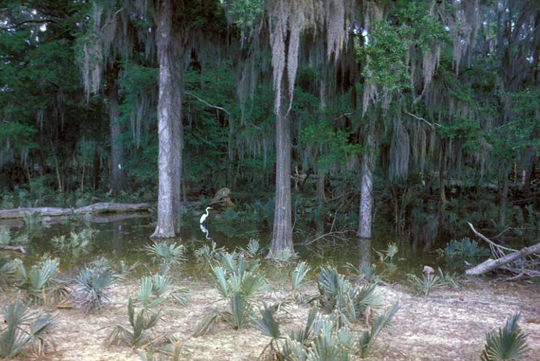
Catahoula Parish. Backswamp, 1961. Photo: Pete Gregory.
Strangers to the Delta often comment on how flat and wet it is, but the people native to the area deny that and can see a bump on the landscape down to a 12-inch variation in elevation! Delta folks divide the place up into a complicated series of landscapes. First, they distinguish between "front land" and "back land," between levee or ridge land, and swampland. Those distinctions result from their knowledge of the land itself. The river, in both its modern and ancient channels, built up heavy sand bars; then in floods, it dropped its fine silts outside that area, building up a natural levee. On the Mississippi, these natural levees may be two to three miles wide, dropping gently away from the river into swamps (sometimes called backswamps or dismal swamp). While the levee land often escaped major floods, flooding was nearly an annual event in the backswamps. The backswamp soils were "buckshot"—firable clay soils inter-fingered with natural levee silts. Farmers and planters were attracted to the "front," while the flood prone "back" attracted stockmen, fisherfolk, and trappers. By 1850, much of the fine levee land had been cleared and cotton became the dominant vegetation. The backswamps, holding water much of the year, were covered in palmetto and canebrakes with a giant upper story of hardwood timber. Trees draped with giant vines and Spanish moss climbed over a hundred feet in places, tying the land and water to the sky.
Anywhere in the Delta by 1930, one could always find a plantation juxtaposed between the river and its great swamps. Cold air drained away from the natural levee into the swamps, making some years almost frost free, and tempering the cold even in the wet swamps. In some ways, the Delta was very reminiscent of tropical rain forests.
By 1940, the lumber companies had begun logging the giant cypress trees and other hardwoods. Sawmills were a major economic focus in the backlands so that by the 1970s, virtually all the virgin forest had been destroyed, and only small second-growth timber prevailed. Paper mills sprang up to exploit even those trees!
The backswamps began to see drainage projects as artificial levees, raised some 70 to100 feet or more, stretched for hundreds of miles. Supposedly for protection, the levees had to rise higher and higher as they more closely confined the river to its banks. Towns that had developed first along the Mississippi were now oriented towards the railroads, often along the margins of the backswamps where trains hauled away lumber from the sawmills. The steamboat, which drew towns to the rivers, gave way to the railroads that, in turn, lost ground to the automobile. The land molded all those economic developments, even in the face of a massive technological impact.
The late William "Uncle Billy" Hampton put it well in the 1970s in Concordia Parish: "The front land has become the back, and the back land the front." Soybeans, milo and rice, which grew well on heavier clay soils and tolerated the sticky "gumbo" clays of the backswamp, flooded those areas. Fleets of bulldozers and draglines cleared and drained thousands of acres almost overnight. The giant hardwood forests were lost, perhaps forever, between 1970 and 1978. Floods were now fewer, levees higher, drainage ditches deeper, and the swamps shrunk faster and faster.
Cotton fell to cattle and beans, as the "front" became the "back." Plantation houses—raised cottages or Greek revival structures built to withstand the heat and humidity—were replaced by houses with central air and heat, built on concrete slabs, like western ranch houses!
Deer and bear, along with smaller game and birds, retreated further and further into the swamps. The deer became addicted to the new bean fields, and fell easy prey to the night hunter's illegal lights and rifles. The bear moved south into the Atchafalaya basin with bulldozers and bean farmers in hot pursuit. Loggers and pulpwood haulers went further and further to chop with their chainsaws, while some of their neighbors grew prosperous clearing the woods with their bulldozers.
Levees and canals confounded the commercial fishermen. The large buffalo fish could not enter the slow bayous and swamps to spawn and their numbers diminished. Bayous and lakes began to silt up as thousands of acres were stripped of vegetation. Even the catfish, lovers of mud, began to suffer.
In 1987, the late William Baker, a corporate farm manager in Catahoula Parish, spoke eloquently of what had transpired:
I came from Missouri and I had heard my father and grandfather talk about clearing the Missouri bottoms. I never thought I'd experience anything like that; then I saw this place.
We cleared, drained, and farmed the land. In the process we destroyed a whole way of life, and in its place we have put a new one. What it had taken hundreds of years to develop was gone in a matter of weeks. These people will never be the same. I helped do here what my folks had done in Missouri a hundred years earlier.
Not since "King Cotton" and slavery had so many changes been seen in the Delta. The thousands of waterfowl, deer, bear, alligator, and other forms of wildlife, once indigenous to these wetlands, were disappearing just as the landscape was changing. Giant soybean elevators competed with cotton gins to dominate a skyline once marked only by giant Bald Cypress or by a rare oil derrick.
Within the great alluvial "cove" of the ancient Arkansas River—always called Macon (pronounced Mason) Ridge in the Delta—once rich forests, then starving cotton lands, were transformed into bean farms. At Little Missouri in the north, these fields blanketed thousands of acres of the ridge. Yeoman farmers were almost instantly replaced by vast corporate land holdings. Always flood free, the "Ridge" was the first to change.
Near Winnsboro in Franklin Parish, the heavy clays under the ridge had formed prairies, often the home of bison in ancient times, but by 1990, they were being transformed into hundreds of acres of catfish ponds. Corn fed, the fish have replaced even the "Golden Bean." Once the lonely fisherman's livelihood, the catfish are now a farmer's crop.
Levees, the massive earthworks that frequently operate to mark the manmade boundary between land and water in the Mississippi Valley, now dwarf the mounds left by the Indians. The old fear of the river is less strong, but respect for its power and whimsy remains. Some of the older towns like Waterproof have moved away from the river as many as four times. Others like Vidalia contain only a few relics of their early days as the river has subsumed the older sites completely. Still, the levee dominates miles and miles of the landscape. In some places, the levee was the refuge in times of flood when the Mississippi filled its banks and the tributaries backed up inside the levee and flooded everywhere. Tents strung along the levees for miles and limited travel along the top of the levee.1
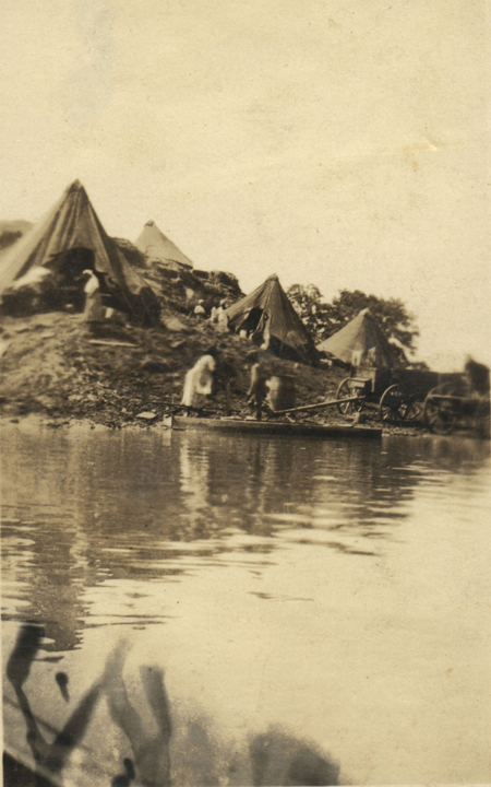
Refugees from flooding camped on Jonesville Mound, n.d. Photo: Dormon Collection, Northwestern State University.
At Ferriday, the black folks found the old abandoned levee high enough to provide a burial place, a place where the water table was not waiting on the coffins. In the country, Indian mounds provided similar space for the dead; and in the Black River country, yeoman farmers and fisherfolk built mounds, direct copies of the existing Indian mounds, to accommodate graveyards, houses, and barns. Everywhere the levees were a part of local tradition: fishermen lived "across the levee," people courted "on the levee," and cattle "grazed the levee," and during floods diligent watchmen quietly "rode the levees." People remembered the great breaks in the levees, especially those of the 1927 and 1937 floods. Old timers could point out the crevasses, the French term for a levee break, gouged and filled by those rushes of river through the walls of earth.
A geologist once said that the only way to control the Mississippi River was to pave the entire riverbed from bank to bank. After the major flood in 1945, the U.S. Army Corps of Engineers began a series of revetments, literally paving the banks with rows of concrete mats. Generations of slaves, Chinese and Irish laborers, and poor whites once worked at the task of controlling the river. They remembered "Do Right," the overseer's heavy black whip; they recalled people killed in the construction and bones buried in the levee, now long forgotten.
By the time people in the Delta reach adolescence, they have a rich vocabulary of river terms: bends, cut-offs, islands, points, or sandbars. Even the eddies and "holes" are named pieces of landscape, as are Esperance Point, the Giles Towhead, Davis Island Cut, and on and on. The oxbow lakes, left as the river meandered away, had their island sides and their bottomless "blue holes" where hapless black victims of the Delta's fierce segregation were reputed to have disappeared. People also feared the "snags" and "deadmen" that lay hidden in the water, like some kind of morbid fingers waiting to punch holes in their boats, capsize them, and add them to others lost to the river.
Fishermen, more than all others, lived in an uneasy detente with the river. It fed them and allowed them to float on its waters, but it promised them little more than freedom and often drowned or threatened them with death. Along with generations of steam boaters, rafters, and barge captains, the fishermen left their names and terms on the land and the water. In many places the fishermen, their houseboats, and their shacks outside the levee have disappeared. But, on the islands and sandbars, in the backswamps along the Black and Ouachita Rivers, one can still see commercial fishermen pulling nets, fishing lines, and, sometimes illegally using old outmoded crank telephones to "call up catfish." When they think of fish bait, their response is still "silver bait works best" [meaning coins paid for information on where to find fish]. Bumper stickers proclaim that one should "Preserve an endangered species: save a commercial fisherman." The river gave its fish and rich soils, but it drowned and flooded, and let people know they were a weak match for its power.
Note
1. See The Flood of 1927 and the Great Depression for more on their impact on the Northeast Louisiana Delta.
