
VIRTUAL BOOKS

Introduction to Delta Pieces: Northeast Louisiana Folklife
Map: Cultural Micro-Regions of the Delta, Northeast Louisiana

The Louisiana Delta: Land of Rivers
Ethnic Groups
Working in the Delta
Homemaking in the Delta
Worshiping in the Delta
Making Music in the Delta
Playing in the Delta
Telling Stories in the Delta
Delta Archival Materials
Bibliography


 them. <br><em>Contains photos.</em>")

Reflections on the Delta - Indian Mounds
By Hiram Ford "Pete" Gregory, III
Editor's Note: In the early 1990s, Pete Gregory wrote these personal reflections about Northeast Louisiana's Delta and they are published with minimal editing. Also see his Musings on the Louisiana Delta from a Native Son.
Indian Mounds
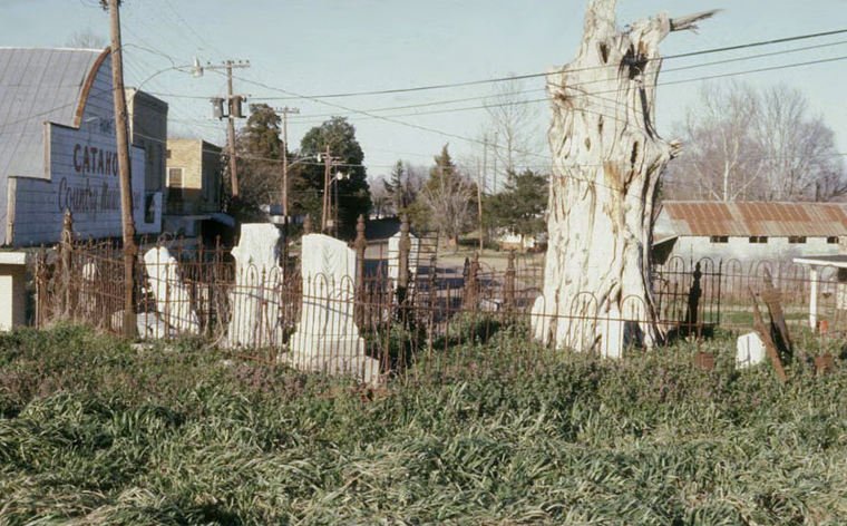
Cemetery on Indian mound, Front St. in Jonesville, ca. 1975. Photo: Pete Gregory.
The Delta is a vast wetland. Not much of it rises above sea level by as much as a hundred feet. Moreover, it has been planed by the lateral swings of the Mississippi and its tributaries until it appears, to the normal human eye, to be flat. Still, to Delta people it has its highs and lows, natural levees and backswamps.
Aside from the giant artificial levees along the rivers, the highest places in the Delta are the mounds built by Indian people. Since the beginning of European expansion into the Delta, these monuments have reminded the Delta of Indian people. There was little belief here that they were the work of any other race or of giants called mound builders. They were Indian mounds. The French colonists saw the Natchez and Tensas mounds still in use as temple bases or the foundations for their ranked chiefs' houses. That knowledge was passed on to the people who replaced them on the land. As early as the Jeffersonian explorations, the mounds like those at Jonesville were reported as remarkable products left by the Indians. The first Smithsonian explorers came to the Delta mounds to see the mounds.
Euro-American settlers speculated about the mounds. As farmers, they knew what it took to pile up the massive amounts of dirt in the mounds. The "myth of removal" that the Indians were all dead or moved to Oklahoma followed the American expansion into the Delta and added to the mythic quality of the mounds. The mounds were, after all, useful to the Americans. In the flood-prone Mississippi valley, they were often the only refuges for people and livestock. These practices took their toll on the structures, but people did not tear them down.
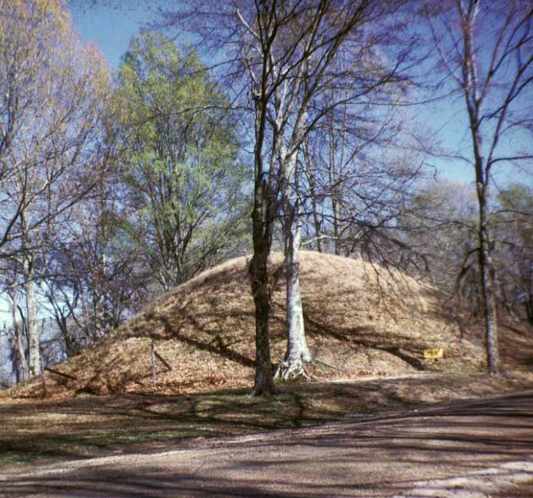
Indian mound in Marksville, Avoyelles Parish, ca. 1980. Photo: Pete Gregory.
In some cases, the Scots-Irish tendency to elevate success by building things higher resulted in large farmhouses sitting atop the mounds. In other cases, the high water table of the Delta made graves inhospitable and the mounds became burial places for whites and blacks in the neighborhood. Many remain so. Along the Black River, Anglo settlers moving from the Carolinas soon occupied the ancient mounds and, using mules and slips, began building their own. These were used for stock refuges, house and barn sites, and in many cases, cemeteries. When archaeologists came in the 19th century seeking antiquities, they were turned away. The Indian mounds were needed for stock refuges, and the water was rising. They did not notice which ones were "new."
Today, the most ancient of all the known American Indian mounds and earthworks sit along the edge of Delta. Ironically, one of these sites takes its name from a former plantation called Poverty Point. It was, as archaeologists have decided, a very large community with a large, bird-shaped mound dominating a town plan of concentric ridges along the Bayou Macon. The site, now protected and in a state park, is shorn of the forest, out of cultivation, and is an international tourist destination. Dating to 1000 B.C. or so, it was the site of one of the largest communities in the New World.1
Further west, another mound group built atop a large levee protrudes into the Ouachita River floodplain off the escarpment. Called Watson Brake, it had five or six mounds with human habitations about them. Archaeological testing suggests these are older than their counterparts in Mexico, some 4,000 or 5,000 years old. Where in the 19th century people speculated that, like Indian maize, the mound building echoed Mexican Indian "civilization," local tourism offices now argue the reverse! Mounds, at least, seem older here in the Delta. So the tourists—mostly school children and teachers—ride about the park trying to wrap their minds around these things being older than Jesus, that Indian folks had a religion, and that their religion had everything to do with the mounds. Archaeologists wander about digging in the sacred land, trying in their own way to answer those same questions.
At Jonesville after a couple of generations of razing mounds for development, local folks are now following the old Black River American tradition and building a facsimile of their "Great Mound" so they can show the passing tourists that the Indian folks left them a heritage, too. Not far away, deep plowing, canal excavation, and levee construction has to fuss with federal and state laws about what they can and cannot do to the mounds.
American Indians—Caddo, Tunica-Biloxi, Choctaw, Chitimacha, and others—ask why people do not respect the past. They ask that same question all across the Delta, where land leveling grinds down the mounds. The mounds remain in spite of all this, a major portion of the Delta landscape and still the biggest hills on the horizon, built by the Indians a long time ago.2
Notes
1. For more information about Poverty Point, see Ouachita River Mounds: A Five Millennium Mystery.
2. For maps of the mounds in Louisiana, visit Indian Mounds of Northeast Louisiana.
